 Filter: Categories of Wisconsin Historical Images
Filter: FULL_DATE of 1969
Filter: Subject of human settlements
Filter: Categories of Wisconsin Historical Images
Filter: FULL_DATE of 1969
Filter: Subject of human settlements

| Date: | 1969 |
|---|---|
| Description: | A map of the Elroy-Sparta State Trail and the surrounding area, showing the townships, the towns of Cashton, Sparta, in the west, and Union Center and Elro... |

| Date: | 1969 |
|---|---|
| Description: | Map showing St. Croix Falls and Taylors Falls, Minnesota. The map was produced by the St. Croix Falls Chamber of Commerce and Taylor Falls Commercial Club.... |

| Date: | 1969 |
|---|---|
| Description: | This photograph was likely taken by the International Harvester Overseas Division for promotional purposes. This photograph shows a long line of Internatio... |

| Date: | 1969 |
|---|---|
| Description: | This photograph was likely taken by the International Harvester Overseas Division for promotional purposes. It shows students wearing school uniforms and h... |

| Date: | 1969 |
|---|---|
| Description: | This photograph was likely taken by the International Harvester Overseas Division for promotional purposes, and shows students in school uniforms with book... |
| Date: | 1969 |
|---|---|
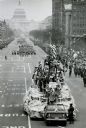
| Description: | Scout pulls a parade float full of people. |

| Date: | 1969 |
|---|---|
| Description: | This street map was given out by Mound City Bank and features a legend of points of interest and a street index. Streets are labeled as is the Roundtree Br... |

| Date: | 1969 |
|---|---|
| Description: | This map is pen and ink on paper and shows the location of churches, local streets, railroads, parks, Middleton, Shorewood Hills, Monona, Maple Bluff, McFa... |

| Date: | 1969 |
|---|---|
| Description: | A view from near the main house at Black Point Estate shows the brick drive and walk in the foreground. Geneva Lake is seen in the background, framed by a... |

| Date: | 1969 |
|---|---|
| Description: | This map shows ghost towns, Indian reservations, lakes, railroads, and rivers. Ghost towns are numbered and listed in a corresponding index. |

| Date: | 1969 |
|---|---|
| Description: | This map shows ski areas, resorts, camps, special areas, airports, and roads. The map covers Vilas and Oneida counties and parts of Iron, Price, Lincoln, L... |

| Date: | 1969 |
|---|---|
| Description: | This map shows businesses, resorts, roads, public boat landings, schools, cemeteries, and location of fish and game. An inset map reads: Continuation along... |

| Date: | 1969 |
|---|---|
| Description: | View of three men harvesting cranberries from a bog. Caption reads: "Greetings from Lac du Flambeau, Wis." |
| Date: | 1969 |
|---|---|
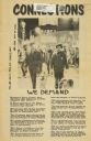
| Description: | Front page of Connections. Features a photograph of a group of people and two dogs walking down State Street, with the Wisconsin State Capitol in th... |

| Date: | 1969 |
|---|---|
| Description: | An ice storm has coated the trees beside Highway 32 between Waheno and Laona. A guard rail is in the foreground. |
| Date: | 1969 |
|---|---|
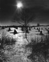
| Description: | Shocks of corn or grain standing in a snow-covered field. A lone tree and foliage is in the foreground. More trees and a fence are in the background. The s... |

| Date: | 1969 |
|---|---|
| Description: | Snowmobiles and drivers lining up before the start of a United States Snowmobile Association sanctioned race. Miller Brewing was a sponsor for the event. |
| Date: | 1969 |
|---|---|
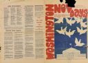
| Description: | Front and back of brochure for Washington Nov Days. Text on front reads: "New Mobilization Committee, Join the Mobilization November 13 15." There is an il... |
| Date: | 1969 |
|---|---|
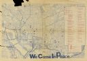
| Description: | Inside spread of brochure for "Washington Nov Days" featuring a map of Washington, D.C. Text at the bottom reads: "We Come In Peace." A key on the right li... |

| Date: | 1969 |
|---|---|
| Description: | A map of Wisconsin from The Atlas of the Eight Counties of Forest, Florence, Iron, Langlade, Lincoln, Oneida, Price, Vilas. The map shows rivers and a vari... |
If you didn't find the material you searched for, our Library Reference Staff can help.
Call our reference desk at 608-264-6535 or email us at: