Filter: Categories of Wisconsin Historical Images
Filter: FULL_DATE of 1968
Filter: Year of 1900-1999
Filter: Subject of streets
Filter: Categories of Wisconsin Historical Images
Filter: FULL_DATE of 1968
Filter: Year of 1900-1999
Filter: Subject of streets
| Date: | 1968 |
|---|---|
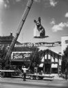
| Description: | Large mouse being lifted by crane onto Bennett's Table Talk at 211-213 Broadway. |

| Date: | 1968 |
|---|---|
| Description: | Close-up of tools on the back of a tar wagon on West 181st Street. Tar soaked brooms glisten in the sun and a pot of tar loosely covered with a hub cap si... |
| Date: | 1968 |
|---|---|
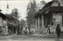
| Description: | Refugees at a Red Cross aid station in Hue shortly after the Tet offensive left much of the city in ruins. This scene was witnessed by American journalist ... |
| Date: | 1968 |
|---|---|
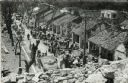
| Description: | Elevated view of refugees after the Tet Offensive, camped out front of their damaged homes. Although not identified, it is believed the image is a street s... |
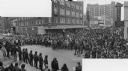
| Date: | 1968 |
|---|---|
| Description: | Composite photograph of an elevated view of an anti-Vietnam War protest at the intersection of Lake and State Streets looking east up State Street. A large... |

| Date: | 1968 |
|---|---|
| Description: | A tourist map of Milwaukee County and of downtown Milwaukee. The Map of Milwaukee County identifies the location of some of the points of interests in the ... |
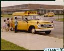
| Date: | 1968 |
|---|---|
| Description: | View towards a group of students boarding an International C-1100 school bus outside Springfield North School. A manis sitting in the driver's seat. |
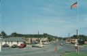
| Date: | 1968 |
|---|---|
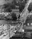
| Description: | Elevated view of the main business district. Cars are parked in front of businesses, and are driving down the road. A flagpole and stop signs are in the fo... |
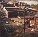
| Date: | 1968 |
|---|---|
| Description: | Elevated view looking down over the railroad station district. |

| Date: | 1968 |
|---|---|
| Description: | This map shows local streets, wards, buildings, parks, and part of the Fox River. The map is also indexed by street name. Ward borders and numbering and th... |

| Date: | 1968 |
|---|---|
| Description: | Three maps that show local streets, roads, railroads, parks, country clubs, the University of Wisconsin, Shorewood Hills, Maple Bluff, Monona, Truax Field,... |

| Date: | 1968 |
|---|---|
| Description: | This blue line print shows lot numbers and dimensions, existing or platted streets and highways, streets and highways to be widened, future streets, and vi... |

| Date: | 1968 |
|---|---|
| Description: | This blue line print map shows proposed changes reserving railroad right-of-ways for future highways, land plots, as well as Lake Monona and Lake Mendota. |

| Date: | 1968 |
|---|---|
| Description: | View from side of street towards a marching band playing as they march in formation down a street. |

| Date: | 1968 |
|---|---|
| Description: | Aerial view looking southwest, with Lake Mendota at right and East Gorham Street running from the bottom left corner. Lincoln School is in the foreground, ... |

| Date: | 1968 |
|---|---|
| Description: | Air view of the University of Wisconsin-Madison campus looking north to Lake Mendota. Picnic Point, currently part of the Lakeshore Nature Preserve, and Ca... |
If you didn't find the material you searched for, our Library Reference Staff can help.
Call our reference desk at 608-264-6535 or email us at: