 Filter: Categories of Wisconsin Historical Images
Filter: FULL_DATE of 1968
Filter: Subject of formations (geology)
Filter: Categories of Wisconsin Historical Images
Filter: FULL_DATE of 1968
Filter: Subject of formations (geology)
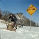
| Date: | 1968 |
|---|---|
| Description: | A Wisconsin game warden removes a dead deer in the snow that had been struck by a vehicle from a rural Vernon County highway next to a deer crossing sign. |

| Date: | 1968 |
|---|---|
| Description: | Elevated view from steep hill of vehicles traveling on the tree-lined Henry Hudson Parkway. |

| Date: | 1968 |
|---|---|
| Description: | This map shows lakes, rivers and soil types. Lake Michigan, Lake Superior, and portions of Illinois, Iowa, Michigan, and Minnesota are labeled. A legend to... |

| Date: | 1968 |
|---|---|
| Description: | A topographic map of east central Wisconsin, that covers an area stretching from Green Bay on the east to Edgar and Vesper on the west, Wausau on the north... |

| Date: | 1968 |
|---|---|
| Description: | This map is ink and color on printed grid. Shows geology, portage trails, timber type, some landownership, hydrology, and marshes in part of Florence Count... |

| Date: | 1968 |
|---|---|
| Description: | A man, woman, and young child standing outside a Scout 810 convertible. They are parked on a road near a sign that reads: "Petroglyphs." The Scout is pulli... |
If you didn't find the material you searched for, our Library Reference Staff can help.
Call our reference desk at 608-264-6535 or email us at: