 Filter: Categories of Wisconsin Historical Images
Filter: FULL_DATE of 1968
Filter: Type of Map or Atlas
Filter: Subject of land
Filter: Categories of Wisconsin Historical Images
Filter: FULL_DATE of 1968
Filter: Type of Map or Atlas
Filter: Subject of land

| Date: | 1968 |
|---|---|
| Description: | This map shows lakes, rivers and soil types. Lake Michigan, Lake Superior, and portions of Illinois, Iowa, Michigan, and Minnesota are labeled. A legend to... |

| Date: | 1968 |
|---|---|
| Description: | A topographic map of east central Wisconsin, that covers an area stretching from Green Bay on the east to Edgar and Vesper on the west, Wausau on the north... |
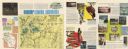
| Date: | 1968 |
|---|---|
| Description: | This 1960s tourism brochure for Sawyer County, Wisconsin, includes descriptive text, color illustrations, a road map, a distance map, a location map, and l... |

| Date: | 1968 |
|---|---|
| Description: | This map is ink and color on printed grid. Shows geology, portage trails, timber type, some landownership, hydrology, and marshes in part of Florence Count... |

| Date: | 1968 |
|---|---|
| Description: | This map shows local streets, wards, buildings, parks, and part of the Fox River. The map is also indexed by street name. Ward borders and numbering and th... |

| Date: | 1968 |
|---|---|
| Description: | This blue line print shows lot numbers and dimensions, existing or platted streets and highways, streets and highways to be widened, future streets, and vi... |
If you didn't find the material you searched for, our Library Reference Staff can help.
Call our reference desk at 608-264-6535 or email us at: