 Filter: Categories of Wisconsin Historical Images
Filter: FULL_DATE of 1967
Filter: Subject of aerial photographs
Filter: Categories of Wisconsin Historical Images
Filter: FULL_DATE of 1967
Filter: Subject of aerial photographs
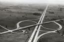
| Date: | 1967 |
|---|---|
| Description: | Intersection of US Highway 41 and Wisconsin Highway 26 near Oshkosh. |
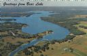
| Date: | 1967 |
|---|---|
| Description: | Aerial view of Bear Lake, with surrounding forests and farms. Caption reads: "Greetings from Bear Lake." |
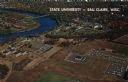
| Date: | 1967 |
|---|---|
| Description: | Aerial view of the State University adjacent to the Chippewa River. Caption reads: "State University - Eau Claire, Eau Claire, Wis." |
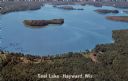
| Date: | 1967 |
|---|---|
| Description: | Aerial view of a lake with islands surrounded by forest. Text on reverse reads: "Joined by a navigable water channel to Lost Land Lake this combined wat... |
| Date: | 1967 |
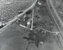
|---|---|
| Description: | Aerial view of what is identified by the caption as a "Nuclear power plant near Victory (Vernon Co.), Wis." This would be the La Crosse Boiling Water React... |

| Date: | 1967 |
|---|---|
| Description: | Air view looking north toward Lake Mendota. The intersection of West Washington Ave. and S. Park Street is at bottom center. The Triangle Redevelopment Pro... |
If you didn't find the material you searched for, our Library Reference Staff can help.
Call our reference desk at 608-264-6535 or email us at: