Filter: Categories of Wisconsin Historical Images
Filter: FULL_DATE of 1967
Filter: Type of Photograph
Filter: Categories of Wisconsin Historical Images
Filter: FULL_DATE of 1967
Filter: Type of Photograph
| Date: | 1967 |
|---|---|
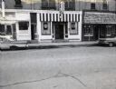
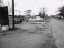
| Description: | A row of three storefronts along State Highway 21 & 73 in Wautoma, Wisconsin. One store front is clearly a bar; a second, whose original front has been gr... |
| Date: | 1967 |
|---|---|
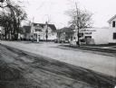
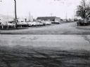
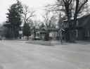
| Description: | A Wautoma, Wisconsin neighborhood. On both sides of the street in both the foreground and middle distance are service stations, beyond them is a residenti... |
| Date: | 1967 |
|---|---|
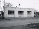
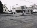
| Description: | A Standard Oil service station located on Oxford Street (State Highway 21&73) in Wautoma, Wisconsin. This photograph relates to the neighborhood view in 3... |
| Date: | 1967 |
|---|---|
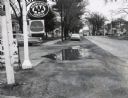
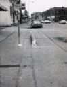
| Description: | Traffic on Oxford Street (State Highway 21&73), with a parking meter in the foreground and old storefronts in the distance. |
| Date: | 1967 |
|---|---|
| Description: | Deep Rock gasoline service station located at the intersection of Scott Street and Oxford Street (STH 21&73) in Wautoma, Wisconsin. |
| Date: | 1967 |
|---|---|
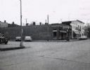
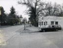
| Description: | Storefronts at the intersection of St. Marie Street and Oxford Street (STH 21&73) in Wautoma, Wisconsin. |
| Date: | 1967 |
|---|---|
| Description: | Zephyr gasoline station on STH 21&73 in Wautoma, Wisconsin. |
| Date: | 1967 |
|---|---|
| Description: | Mobil Oil service station on the corner of STH 22 and STH 21&73. |

| Date: | 1967 |
|---|---|
| Description: | Sinclair station located on STH 21, 22 & 73 in Wautoma, Wisconsin. |
| Date: | 1967 |
|---|---|
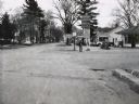
| Description: | Northwestern Street intersection in Wautoma, with the old railroad depot in the background and a parking lot in the foreground. |
| Date: | 1967 |
|---|---|
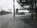
| Description: | Waupaca Tree Service at the intersection of STH 24 and King Road with station wagon parked in front. |
| Date: | 1967 |
|---|---|
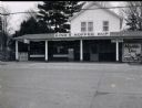
| Description: | King's Koffee Kup, a restaurant located on STH 22. |
| Date: | 1967 |
|---|---|
| Description: | Bungalow-style house located on STH 22, that had been converted into a beer garden and bait shop. |
| Date: | 1967 |
|---|---|
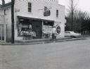
| Description: | Carlson's One Stop Market located on STH 22. |
| Date: | 1967 |
|---|---|
| Description: | Handle's Bar and Motel, located along STH 22 in King, Wisconsin, at the intersection with Grand View Road. Another motel can be seen in the distance acros... |

| Date: | 1967 |
|---|---|
| Description: | The Clark Oil Company station at the corner of State Highway 73 & 21 and Baxter Avenue. |

| Date: | 1967 |
|---|---|
| Description: | Outdoor view of two pots used for a fish boil. One pot is engulfed in flames and children are running from the area. |
| Date: | 1967 |
|---|---|
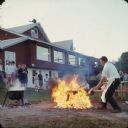
| Description: | A man fueling a fire for a fish boil, as people look on. |
| Date: | 1967 |
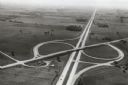
|---|---|
| Description: | Intersection of US Highway 41 and Wisconsin Highway 26 near Oshkosh. |
If you didn't find the material you searched for, our Library Reference Staff can help.
Call our reference desk at 608-264-6535 or email us at: