 Filter: Categories of Wisconsin Historical Images
Filter: FULL_DATE of 1966
Filter: Subject of transportation
Filter: Categories of Wisconsin Historical Images
Filter: FULL_DATE of 1966
Filter: Subject of transportation
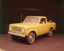
| Date: | 1966 |
|---|---|
| Description: | Passenger side view of yellow Scout II pickup, with a spare tire mounted on the inside of the truck bed. |
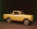
| Date: | 1966 |
|---|---|
| Description: | Three-quarter view from front of driver's side of yellow Scout II pickup truck. Spare tire is mounted on the inside of the truck bed. |

| Date: | 1966 |
|---|---|
| Description: | Three-quarter view from rear of red International Scout pickup, with yellow snow plow attached on front. The Scout is being used to plow snow in front of g... |

| Date: | 1966 |
|---|---|
| Description: | Close-up of front of Scout, including headlights, section of front hood with "IH" insignia, and "INTERNATIONAL" plate on grille. |

| Date: | 1966 |
|---|---|
| Description: | View over gas pumps of a man using an International Scout pickup to plow snow at a Citgo service station. The Scout is painted red, and the snow plow is pa... |

| Date: | 1966 |
|---|---|
| Description: | View from front of man driving red International Scout pickup with yellow snow plow on front. He is plowing at a Citgo service station. |

| Date: | 1966 |
|---|---|
| Description: | A colored map depiction of Door County, Wisconsin, with pictorial highlights, titled: "Door County — Wisconsin's Air Conditioned Peninsula Playground." |
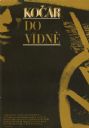
| Date: | 1966 |
|---|---|
| Description: | Czechoslovakian film poster. Black and mustard yellow image of a carriage wheel in the bottom right corner and part of a face in the top left corner. |

| Date: | 1966 |
|---|---|
| Description: | This map shows streets, highways, railroads, parks, colleges, cemeteries, county clubs, University of Wisconsin, Truax Field, Middleton, Shorewood Hills, M... |

| Date: | 1966 |
|---|---|
| Description: | This map shows city, suburban, parochial and other types schools, with an explanation of symbols in the right margin. The original caption for the map read... |

| Date: | 1966 |
|---|---|
| Description: | This map shows arterial roads. Original caption reads, "Approved July 7, 1996 by State Highway Commission of Wisconsin." Includes a symbol key in the lower... |

| Date: | 1966 |
|---|---|
| Description: | This map includes a red overprint on base map and shows the supervisors and district numbers of St. Croix County. Includes diagrams of civil towns, townsh... |

| Date: | 1966 |
|---|---|
| Description: | View from grassy shoreline of the old covered bridge across Cedar Creek. |

| Date: | 1966 |
|---|---|
| Description: | This map shows trails, roads, creeks, alleged location of George Gardner's trading post, Boulder and Mud Lakes, and a portion of the Wolf River. The map al... |

| Date: | 1966 |
|---|---|
| Description: | This blue line print shows existing and proposed streets, docks, company-owned land, railroads and railroad yards, parks, and municipal airport. |
| Date: | 1966 |
|---|---|
| Description: | Service station located at 601 West Washington Avenue, on the intersection with South Bedford Street. This is the view from South Bedford Street. In the ba... |
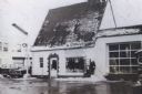
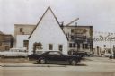
| Date: | 1966 |
|---|---|
| Description: | Service station located at 601 West Washington Avenue, on the intersection with South Bedford Street. This is the view from West Washington Avenue, and sno... |

| Date: | 1966 |
|---|---|
| Description: | This colored road map shows automobile roads in Wisconsin as well as portions of nearby states. Information on the quality and type of any road shown (inte... |

| Date: | 1966 |
|---|---|
| Description: | This colored road map shows automobile roads in Wisconsin as well as portions of nearby states. A map key indicates relative sizes of cities and towns. On ... |

| Date: | 1966 |
|---|---|
| Description: | This colored road map shows automobile roads in Wisconsin as well as portions of nearby states. Information on the quality and type of any road shown (inte... |
If you didn't find the material you searched for, our Library Reference Staff can help.
Call our reference desk at 608-264-6535 or email us at: