 Filter: Categories of Wisconsin Historical Images
Filter: FULL_DATE of 1966
Filter: Subject of railroads
Filter: Categories of Wisconsin Historical Images
Filter: FULL_DATE of 1966
Filter: Subject of railroads

| Date: | 1966 |
|---|---|
| Description: | The map shows streets, wells, school land, parks, cemeteries, railroads, and the Delbrook Golf Course. The bottom of the map reads: "January 11, 1962 May 2... |
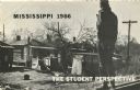
| Date: | 1966 |
|---|---|
| Description: | View from behind of a man standing on railroad tracks surveying a row of dilapidated shanties. Used on the cover of brochure with the title, 'Mississippi 1... |

| Date: | 1966 |
|---|---|
| Description: | This map shows streets, highways, railroads, parks, colleges, cemeteries, county clubs, University of Wisconsin, Truax Field, Middleton, Shorewood Hills, M... |

| Date: | 1966 |
|---|---|
| Description: | This map shows city, suburban, parochial and other types schools, with an explanation of symbols in the right margin. The original caption for the map read... |

| Date: | 1966 |
|---|---|
| Description: | This map includes a red overprint on base map and shows the supervisors and district numbers of St. Croix County. Includes diagrams of civil towns, townsh... |

| Date: | 1966 |
|---|---|
| Description: | This blue line print shows existing and proposed streets, docks, company-owned land, railroads and railroad yards, parks, and municipal airport. |
If you didn't find the material you searched for, our Library Reference Staff can help.
Call our reference desk at 608-264-6535 or email us at: