 Filter: Categories of Wisconsin Historical Images
Filter: FULL_DATE of 1966
Filter: County of Milwaukee
Filter: Subject of cities and towns
Filter: Categories of Wisconsin Historical Images
Filter: FULL_DATE of 1966
Filter: County of Milwaukee
Filter: Subject of cities and towns
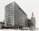
| Date: | 1966 |
|---|---|
| Description: | Angled view of building. An older brick building with a domed tower is behind the Municipal building. |
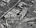
| Date: | 1966 |
|---|---|
| Description: | St. Mary's Hospital and surrounding area. In the bottom left corner is the water tower. |

| Date: | 1966 |
|---|---|
| Description: | This map from the 1960s provides a detailed street map of Milwaukee County and eastern Waukesha County as far west as Menomonee Falls and Muskego Lake. A p... |

| Date: | 1966 |
|---|---|
| Description: | This map shows city, suburban, parochial and other types schools, with an explanation of symbols in the right margin. The original caption for the map read... |
If you didn't find the material you searched for, our Library Reference Staff can help.
Call our reference desk at 608-264-6535 or email us at: