 Filter: Categories of Wisconsin Historical Images
Filter: FULL_DATE of 1965
Filter: Subject of transportation
Filter: Subject of human settlements
Filter: Categories of Wisconsin Historical Images
Filter: FULL_DATE of 1965
Filter: Subject of transportation
Filter: Subject of human settlements
| Date: | 1965 |
|---|---|
| Description: | View of the J.J. Stoner house, located at 321 South Hamilton Street. |

| Date: | 1965 |
|---|---|
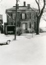
| Description: | Exterior view of the Strelow House, located at 218 North Pinckney Street. |
| Date: | 1965 |
|---|---|
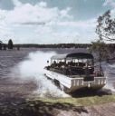
| Description: | Amphibious vehicle known as a Duck splashes into Lake Delton as it carries passengers on a tour of the Wisconsin Dells. |
| Date: | 1965 |
|---|---|
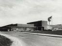
| Description: | Exterior view of International Harvester's Motor Truck Engineering Department. Original caption reads, in part: "...The company also operates a 160,000 sq.... |

| Date: | 1965 |
|---|---|
| Description: | Artistic rendering of the Equitable Building at 401 N. Michigan Avenue. Includes the text "make yours the prestige address in Chicago — the dramatic new Eq... |
| Date: | 1965 |
|---|---|
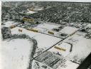
| Description: | Aerial view of the UW-Madison campus near University Bay in winter. Labels are pasted to the print to indicate Elm Dr., the gym, Camp Randall Stadium, the ... |
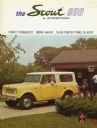
| Date: | 1965 |
|---|---|
| Description: | Cover of an advertising brochure for the International Scout 800, featuring a color photograph of a woman behind the wheel of a Scout truck. There is a you... |

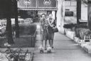
| Date: | 1965 |
|---|---|
| Description: | View down sidewalk of the Clay County welfare office. The caption on the back of the image reports that African-Americans who received welfare were treated... |
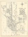
| Date: | 1965 |
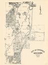
|---|---|
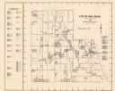
| Description: | Shows city limits, plat of town, local streets, railroads, and Baraboo River. "Revised by Mid-State Associates, Baraboo, Wisconsin, April 6, 1965" Upper ri... |
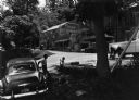
| Date: | 1965 |
|---|---|
| Description: | Several cars are parked outdoors. To the right, a man washes his pickup truck. To the left, a man leans against a car. Nearby, a child is seated on a short... |

| Date: | 1965 |
|---|---|
| Description: | Map shows original plat, plat additions, and lot measurements for Rothschild, Wisconsin. Lake Wausau and the Wisconsin River are labelled. Map reads: "Comp... |
| Date: | 1965 |
|---|---|
| Description: | Two women, one walking a pair of toy poodle dogs, on a sidewalk in front of the Churchill Hotel. |
| Date: | 1965 |
|---|---|
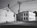
| Description: | Street corner with old Dolly Madison Dairies buildings. |

| Date: | 1965 |
|---|---|
| Description: | View down sidewalk with the porches of duplex residential houses on the left in the downtown area. |
| Date: | 1965 |
|---|---|
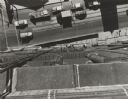
| Description: | Overhead view looking down from a tall building at passing traffic and workmen on suspended scaffolding near the sidewalk. |
| Date: | 1965 |
|---|---|
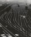
| Description: | Elevated view over railroad yards from the 27th Street viaduct. |

| Date: | 1965 |
|---|---|
| Description: | View looking through porches of residential buildings near Capitol Square. |
| Date: | 1965 |
|---|---|
| Description: | This map shows Milwaukee County Parkway lands, streets, streets not yet constructed, public facilities, schools, churches, and manufacturers. The map inclu... |
| Date: | 1965 |
|---|---|
| Description: | This map shows lot and block numbers and dimensions, additions, streets, and railroads. |

| Date: | 1965 |
|---|---|
| Description: | This map shows lot and block numbers and dimensions, railroads, and streets and is dated: "March 1965." The map includes manuscript annotations that show m... |
If you didn't find the material you searched for, our Library Reference Staff can help.
Call our reference desk at 608-264-6535 or email us at: