 Filter: Categories of Wisconsin Historical Images
Filter: FULL_DATE of 1965
Filter: Subject of school buildings
Filter: Categories of Wisconsin Historical Images
Filter: FULL_DATE of 1965
Filter: Subject of school buildings
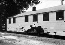
| Date: | 1965 |
|---|---|
| Description: | Back view of a black high school showing damage on a wall. SNCC Arkansas Project. |
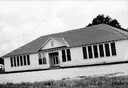
| Date: | 1965 |
|---|---|
| Description: | Front view of a high school for African American students. SNCC Arkansas Project. |
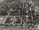
| Date: | 1965 |
|---|---|
| Description: | Aerial view of Iola, Wisconsin looking west. Located in the lower left corner is an elementary school. |
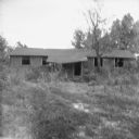
| Date: | 1965 |
|---|---|
| Description: | The school used for African-American children in the western half of Clay County until 1960, pictured 5 years after it closed. |

| Date: | 1965 |
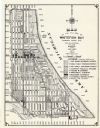
|---|---|
| Description: | This map shows streets, churches, schools, wards, railroads, parks and fields, cemeteries, Historical Museum, Yacht Basin & Marina, and Marinette General H... |

| Date: | 1965 |
|---|---|
| Description: | This map shows wards, schools and public buildings, and polling places. The map includes a street index. Lac La Belle, Fowler Lake, and Oconomowoc Lake are... |
| Date: | 1965 |
|---|---|
| Description: | This map shows 8 zoning districts, as well as house number system, schools, parks, churches, and points of interest. Lake Michigan is labeled and the lower... |
If you didn't find the material you searched for, our Library Reference Staff can help.
Call our reference desk at 608-264-6535 or email us at: