Filter: Categories of Wisconsin Historical Images
Filter: FULL_DATE of 1965
Filter: Subject of rivers
Filter: Categories of Wisconsin Historical Images
Filter: FULL_DATE of 1965
Filter: Subject of rivers

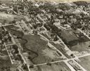
| Date: | 1965 |
|---|---|
| Description: | Aerial view of downtown Big Falls and the Little Wolf River. The Little Wolf River is at lower right. |
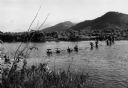
| Date: | 1965 |
|---|---|
| Description: | View from shoreline of U.S. Marines wading across a river while on a "Search and Clear" operation near Da Nang in Vietnam. |

| Date: | 1965 |
|---|---|
| Description: | Artistic rendering of the Equitable Building at 401 N. Michigan Avenue. Includes the text "make yours the prestige address in Chicago — the dramatic new Eq... |

| Date: | 1965 |
|---|---|
| Description: | A map of Milwaukee County showing the county supervisor districts and the city wards. The map also includes the names of those on the on the board of elect... |
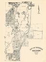
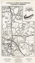
| Date: | 1965 |
|---|---|
| Description: | Shows city limits, plat of town, local streets, railroads, and Baraboo River. "Revised by Mid-State Associates, Baraboo, Wisconsin, April 6, 1965" Upper ri... |

| Date: | 1965 |
|---|---|
| Description: | Map shows original plat, plat additions, and lot measurements for Rothschild, Wisconsin. Lake Wausau and the Wisconsin River are labelled. Map reads: "Comp... |
| Date: | 1965 |
|---|---|
| Description: | This map shows lot and block numbers and dimensions, additions, streets, and railroads. |

| Date: | 1965 |
|---|---|
| Description: | This map shows wards, city limits, railroad right of way, proposed future streets, and approximate street elevations. Wards and public schools are labeled ... |

| Date: | 1965 |
|---|---|
| Description: | This map shows 32 zoning districts, house numbering system, parks, cemeteries, and Milwaukee County institutional buildings. |

| Date: | 1965 |
|---|---|
| Description: | This map shows landownership, acreages, and roads. The city of De Pere, the town of Hobart, and the Fox River are labeled. Inset maps showing Smits Subdivi... |
| Date: | 1965 |
|---|---|
| Description: | This map covers the vicinity of Arbor Vitae, Woodruff, and Minocqua: east to Mishonagon Creek, west to Gilmore Lake, north to Lower Gresham Lake, and south... |

| Date: | 1965 |
|---|---|
| Description: | This series of 17 maps show boundaries and changes in city limits from 1846 to 1965. The base of all of the maps are the same, Milwaukee and suburbs. All m... |
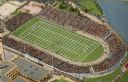
| Date: | 1965 |
|---|---|
| Description: | Overhead view of the football stadium before it was renamed Lambeau. The stadium is full of spectators and a game is in progress. |
If you didn't find the material you searched for, our Library Reference Staff can help.
Call our reference desk at 608-264-6535 or email us at: