Filter: Categories of Wisconsin Historical Images
Filter: FULL_DATE of 1965
Filter: Subject of botany
Filter: Subject of human settlements
Filter: Categories of Wisconsin Historical Images
Filter: FULL_DATE of 1965
Filter: Subject of botany
Filter: Subject of human settlements

| Date: | 1965 |
|---|---|
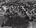
| Description: | Aerial view of downtown Big Falls and the Little Wolf River. The Little Wolf River is at lower right. |

| Date: | 1965 |
|---|---|
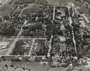
| Description: | Aerial view of town and Highway 66. |

| Date: | 1965 |
|---|---|
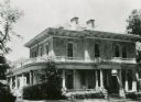
| Description: | The Robert M. Bashford house at 423 North Pinckney Street. |

| Date: | 1965 |
|---|---|
| Description: | The James Bowen House at 302 South Mills Street. There is a station wagon parked in front of the building. |

| Date: | 1965 |
|---|---|
| Description: | The Harold C. Bradley house at 106 North Prospect Avenue. |

| Date: | 1965 |
|---|---|
| Description: | The Harold C. Bradley house, located at 2914 Oxford Road in Shorewood Hills. |
| Date: | 1965 |
|---|---|
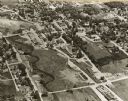
| Description: | Aerial view of Iola, Wisconsin looking west. Located in the lower left corner is an elementary school. |
| Date: | 1965 |
|---|---|
| Description: | The Executive Residence, 130 East Gilman Street. Used as the Executive Residence from 1883-1950. |
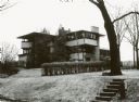
| Date: | 1965 |
|---|---|
| Description: | The Eugene A. Gilmore house, 120 Ely Place, designed by Frank Lloyd Wright, architect. |

| Date: | 1965 |
|---|---|
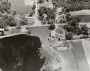
| Description: | Aerial view that encompasses most of the town and part of the Wisconsin River. |
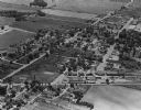
| Date: | 1965 |
|---|---|
| Description: | Aerial view, looking west, with potato warehouses in the foreground and a pallet factory and junkyard behind them at right. |
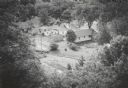
| Date: | 1965 |
|---|---|
| Description: | Elevated view from hill of houses and garages surrounded by trees. |
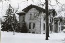
| Date: | 1965 |
|---|---|
| Description: | The Simeon Mills (farm) house, 2709 Sommers Avenue. Snow is on the ground. |

| Date: | 1965 |
|---|---|
| Description: | Aerial view looking north-northwest. View includes houses, roads, farm buildings, tractor-trailors (parked), other buildings. |
| Date: | 1965 |
|---|---|
| Description: | Aerial view, looking east. Highway 49 is at center. |
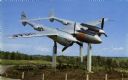
| Date: | 1965 |
|---|---|
| Description: | View of the Bong Memorial, dedicated to the memory of World War II air ace Major Richard I. Bong. This P-38 is the type of plane he piloted when he shot do... |
If you didn't find the material you searched for, our Library Reference Staff can help.
Call our reference desk at 608-264-6535 or email us at: