 Filter: Categories of Wisconsin Historical Images
Filter: FULL_DATE of 1965
Filter: Reproduction Rights of For Sale
Filter: Categories of Wisconsin Historical Images
Filter: FULL_DATE of 1965
Filter: Reproduction Rights of For Sale

| Date: | 1965 |
|---|---|
| Description: | This map shows wards, city limits, railroad right of way, proposed future streets, and approximate street elevations. Wards and public schools are labeled ... |

| Date: | 1965 |
|---|---|
| Description: | This map is indexed for public buildings and includes a numbered key on the lower left side. The streets are labeled and Lake Michigan is labeled on the fa... |

| Date: | 1965 |
|---|---|
| Description: | This map shows streets, churches, schools, wards, railroads, parks and fields, cemeteries, Historical Museum, Yacht Basin & Marina, and Marinette General H... |

| Date: | 1965 |
|---|---|
| Description: | This map shows wards, schools and public buildings, and polling places. The map includes a street index. Lac La Belle, Fowler Lake, and Oconomowoc Lake are... |

| Date: | 1965 |
|---|---|
| Description: | This map shows 32 zoning districts, house numbering system, parks, cemeteries, and Milwaukee County institutional buildings. |
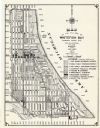
| Date: | 1965 |
|---|---|
| Description: | This map shows 8 zoning districts, as well as house number system, schools, parks, churches, and points of interest. Lake Michigan is labeled and the lower... |

| Date: | 1965 |
|---|---|
| Description: | View over the shoulder of a soldier of the 82nd Airborne firing a .50 machine gun out a high window of Observation Post #1 in Santo Domingo, Dominican Repu... |

| Date: | 1965 |
|---|---|
| Description: | Large group of soldiers with packs and gear in a hangar. More packs and gear are near numbered areas in the foreground. |

| Date: | 1965 |
|---|---|
| Description: | View from rooftop of a blockaded street in Santo Domingo, Dominican Republic, seen from a U.S. Marine position. A large group of civilians, mainly women, s... |
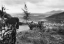
| Date: | 1965 |
|---|---|
| Description: | View from roadside of a number of soldiers riding in the back of a military transport truck along a road on a high hillside with a view of the valley below... |
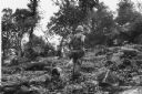
| Date: | 1965 |
|---|---|
| Description: | Three soldiers navigate down a rocky hillside covered with low-lying vegetation. |
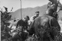
| Date: | 1965 |
|---|---|
| Description: | Six soldiers along a roadside in Vietnam. One soldier operates a radio while another writes. Other men sit on the other side of the road, and in the far ba... |

| Date: | 1965 |
|---|---|
| Description: | A soldier with a radio on his back waits in the foreground while a group of men stand waiting while other men board helicopters on a beach in Vietnam. |
| Date: | 1965 |
|---|---|
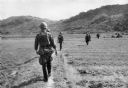
| Description: | Rear view of group of soldiers walking in an open field on a "search and clear" mission near Da Nang. Hills are in the background. |
| Date: | 1965 |
|---|---|
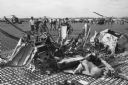
| Description: | Wreckage of a downed helicopter at an airbase in Vietnam. Several soldiers, other helicopters and tents are in the background. |

| Date: | 1965 |
|---|---|
| Description: | Bodies of several dead Viet Cong soldiers lying on a beach. Several U.S. soldiers observe as bodies are placed in the sand from a truck. |

| Date: | 1965 |
|---|---|
| Description: | View of five soldiers in Vietnam, some of whom are reading a map, and others smoking cigarettes. |

| Date: | 1965 |
|---|---|
| Description: | U.S. soldiers drag the body of a dead Viet Cong soldier on a beach. |

| Date: | 1965 |
|---|---|
| Description: | Interior portrait of a farmer and his wife sitting on chairs and eating off paper plates in their laps. There are containers of "Meadow Gold" on their plat... |

| Date: | 1965 |
|---|---|
| Description: | This map shows landownership, acreages, and roads. The city of De Pere, the town of Hobart, and the Fox River are labeled. Inset maps showing Smits Subdivi... |
If you didn't find the material you searched for, our Library Reference Staff can help.
Call our reference desk at 608-264-6535 or email us at: