 Filter: Categories of Wisconsin Historical Images
Filter: FULL_DATE of 1965
Filter: County of Milwaukee
Filter: Categories of Wisconsin Historical Images
Filter: FULL_DATE of 1965
Filter: County of Milwaukee
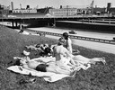
| Date: | 1965 |
|---|---|
| Description: | Women sun bathe near an express highway in Milwaukee. |

| Date: | 1965 |
|---|---|
| Description: | Aerial view of early construction at the Marquette Interchange in Milwaukee, the junction of Interstate Highways I94 and I43. Construction began in 1964, ... |
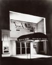
| Date: | 1965 |
|---|---|
| Description: | Nighttime view of theater entrance. Doorway has a fabric overhang with the theatre name printed on each side. Posters for Robert Lewis and Tom Daily flan... |

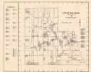
| Date: | 1965 |
|---|---|
| Description: | A map of Milwaukee County showing the county supervisor districts and the city wards. The map also includes the names of those on the on the board of elect... |

| Date: | 1965 |
|---|---|
| Description: | Two men, competitors in a state card-playing (skat) tournament. |

| Date: | 1965 |
|---|---|
| Description: | Head and shoulders view of young couple, seated in subdued light in the Avant Garde Cafe Espresso. |

| Date: | 1965 |
|---|---|
| Description: | Group of four standing women conversing informally at a social occasion. |

| Date: | 1965 |
|---|---|
| Description: | Visitors to the Wisconsin State Fair running for shelter at the onset of a sudden rain shower. |
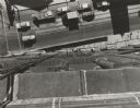
| Date: | 1965 |
|---|---|
| Description: | Overhead view looking down from a tall building at passing traffic and workmen on suspended scaffolding near the sidewalk. |
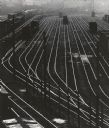
| Date: | 1965 |
|---|---|
| Description: | Elevated view over railroad yards from the 27th Street viaduct. |
| Date: | 1965 |
|---|---|
| Description: | This map shows Milwaukee County Parkway lands, streets, streets not yet constructed, public facilities, schools, churches, and manufacturers. The map inclu... |

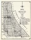
| Date: | 1965 |
|---|---|
| Description: | This map shows wards, city limits, railroad right of way, proposed future streets, and approximate street elevations. Wards and public schools are labeled ... |

| Date: | 1965 |
|---|---|
| Description: | This map is indexed for public buildings and includes a numbered key on the lower left side. The streets are labeled and Lake Michigan is labeled on the fa... |

| Date: | 1965 |
|---|---|
| Description: | This map shows 32 zoning districts, house numbering system, parks, cemeteries, and Milwaukee County institutional buildings. |
| Date: | 1965 |
|---|---|
| Description: | This map shows 8 zoning districts, as well as house number system, schools, parks, churches, and points of interest. Lake Michigan is labeled and the lower... |

| Date: | 1965 |
|---|---|
| Description: | This series of 17 maps show boundaries and changes in city limits from 1846 to 1965. The base of all of the maps are the same, Milwaukee and suburbs. All m... |
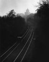
| Date: | 1965 |
|---|---|
| Description: | Elevated view of two railroad lines curving towards the city in the distance. A speeder, a mini maintenance car, is on the left hand track. A gantry is ove... |

| Date: | 1965 |
|---|---|
| Description: | Two African American men smiling while holding a poster. The poster includes a drawing of two smiling police officers and the text: "Milwaukee Policemen ar... |
If you didn't find the material you searched for, our Library Reference Staff can help.
Call our reference desk at 608-264-6535 or email us at: