 Filter: Categories of Wisconsin Historical Images
Filter: FULL_DATE of 1964
Filter: Subject of land use, urban
Filter: Categories of Wisconsin Historical Images
Filter: FULL_DATE of 1964
Filter: Subject of land use, urban

| Date: | 1964 |
|---|---|
| Description: | Aerial view of the Milwaukee County Zoo grounds nearing its completion. |
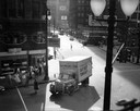
| Date: | 1964 |
|---|---|
| Description: | Elevated view of an International 1700 Loadstar truck owned by George Miesel and Son, wholesale grocers, delivering daily foodstuffs to restaurants and ins... |

| Date: | 1964 |
|---|---|
| Description: | An aerial view of the U.S. Rubber Company plant and surrounding environment. |

| Date: | 1964 |
|---|---|
| Description: | An aerial view of the U.S. Rubber Company plant and surrounding environment. |

| Date: | 1964 |
|---|---|
| Description: | This map of Two Rivers shows the Rodgers street fishing area and land use. The map features a legend on the right of the types of land use. The map also sh... |

| Date: | 1964 |
|---|---|
| Description: | This map shows various zoning sections and includes labeled streets, parks, and cemeteries. The upper left corner contains a legend of land use. |
If you didn't find the material you searched for, our Library Reference Staff can help.
Call our reference desk at 608-264-6535 or email us at: