 Filter: Categories of Wisconsin Historical Images
Filter: FULL_DATE of 1964
Filter: Subject of lakes
Filter: Categories of Wisconsin Historical Images
Filter: FULL_DATE of 1964
Filter: Subject of lakes

| Date: | 1964 |
|---|---|
| Description: | The Queen of the Lake boat launch on State Highway 23 in Green Lake County. |

| Date: | 1964 |
|---|---|
| Description: | This 1964 maps shows roads, boat landings and marinas, campgrounds, canoe trails and portages, and lakes and streams in parts of Vilas, Oneida, and Iron co... |

| Date: | 1964 |
|---|---|
| Description: | Shows local streets, bus routes, highways, airport, Dells Pond, Half Moon Lake, Chippewa River, and Eau Claire River. Includes 2 inset maps: Location map a... |

| Date: | 1964 |
|---|---|
| Description: | Indexed map. Street names are to the left, map is to the right. Lakes, streets, highways, and points of interest are labelled. |

| Date: | 1964 |
|---|---|
| Description: | Baby Paul Arms playing in the water at a beach with his mother LuRay. His sisters Rita and Mamie are in the background. |

| Date: | 1964 |
|---|---|
| Description: | Aerial view of the Sampson Plaza apartment complex on West Washington Avenue, with Proudfit Street running along the bottom. Neighborhood House can be seen... |
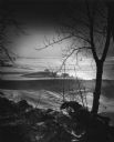
| Date: | 1964 |
|---|---|
| Description: | Snow drifting on Lake Winnebago seen through trees on the shoreline. |
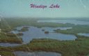
| Date: | 1964 |
|---|---|
| Description: | Text on front reads: "Windigo Lake." On reverse: "Windigo Lake. 7 miles South of Hayward, Wisc. on Hiway 27. Vacation Paradise of Northern Wisconsin." Aeri... |
If you didn't find the material you searched for, our Library Reference Staff can help.
Call our reference desk at 608-264-6535 or email us at: