 Filter: Categories of Wisconsin Historical Images
Filter: FULL_DATE of 1962
Filter: Subject of transportation
Filter: Categories of Wisconsin Historical Images
Filter: FULL_DATE of 1962
Filter: Subject of transportation

| Date: | 1962 |
|---|---|
| Description: | Color photograph of a range light built in 1870 to guide ships into the harbor at The Ridges Sanctuary, north of Bailey's Harbor, Door County. The Ridges S... |

| Date: | 1962 |
|---|---|
| Description: | This blue print map shows 5 zoning districts, as well as lot and block numbers and dimensions, public land, streets, and Mill Pond. The zones are: "Single ... |

| Date: | 1962 |
|---|---|
| Description: | Marine crew chief Nelson West and several South Vietnamese soldiers patrol an area near Vinh Quoi from a helicopter. |

| Date: | 1962 |
|---|---|
| Description: | U.S. Marines posing with a captured Russian flag in front of a helicopter at the Soc Trang U.S. Marine helicopter base in Vietnam. |
| Date: | 1962 |
|---|---|
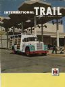
| Description: | Front cover of International Trail magazine featuring a color photograph of a 1600 Loadstar Seven-Up delivery truck, outside the Oklahoma City's Pee... |

| Date: | 1962 |
|---|---|
| Description: | This map shows roads, golf courses, ski areas, boat landings, camp sites, waysides, parks, beaches, scenic views, virgin timber tracts, airports, boys and ... |

| Date: | 1962 |
|---|---|
| Description: | Wayne Van Ryn, final assembly employee, drives the rear-wheel drive model with 4-passenger capacity and bucket front seats off the line. Two men, V.A. Hart... |

| Date: | 1962 |
|---|---|
| Description: | This map shows roads, golf courses, ski areas, boat landings, camp sites, waysides, parks, beaches, scenic views, virgin timber tracts, airports, boys and ... |
| Date: | 1962 |
|---|---|
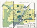
| Description: | This map shows zoning, community facilities, roads, rivers and thoroughfares. The lower right corner includes a key titled "General Plan". |

| Date: | 1962 |
|---|---|
| Description: | View from side of road towards the covered bridge, with the historical marker on the right. "This bridge was built by the town of Cedarburg on petition of ... |
| Date: | 1962 |
|---|---|
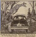
| Description: | Sid's illustration in a newspaper. Two men are sitting in a car driving on a road. A deer is leaping over them. On the bottom, an ode by Sid reads: "We hee... |

| Date: | 1962 |
|---|---|
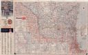
| Description: | This colored road map shows roads in Wisconsin as well as portions of nearby states. The map is organized such that a single map of Wisconsin is divided on... |
| Date: | 1962 |
|---|---|
| Description: | This colored road map shows roads in Wisconsin as well as portions of nearby states. The map is organized such that a single map of Wisconsin is divided on... |

| Date: | 1962 |
|---|---|
| Description: | This tourist-oriented road map shows federal highways, state highways, county roads, and county lines in the "Blue Diamond Resort Area," a scenic space enc... |

| Date: | 1962 |
|---|---|
| Description: | This colored map represents "Tour #2" of a series of driving tours of the state published by the Sperry & Hutchinson Company, in order to "help you enjoy W... |

| Date: | 1962 |
|---|---|
| Description: | This colored map represents "Tour #1" of a series of driving tours of the state published by the Sperry & Hutchinson Company, in order to "help you enjoy W... |
| Date: | 1962 |
|---|---|
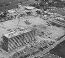
| Description: | Aerial view of the Hill Farms State Office Building, 4802 Sheboygan Avenue, during construction. |
| Date: | 1962 |
|---|---|
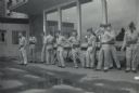
| Description: | A group of soldiers waiting together to go to Fort Knox. |

| Date: | 1962 |
|---|---|
| Description: | Lewis Arms (fourth from right) waiting with other soldiers to leave for Fort McCoy. |

| Date: | 1962 |
|---|---|
| Description: | Lewis Arms is sitting on an airplane as he and other soldiers travel to Fort Knox. |
If you didn't find the material you searched for, our Library Reference Staff can help.
Call our reference desk at 608-264-6535 or email us at: