 Filter: Categories of Wisconsin Historical Images
Filter: FULL_DATE of 1962
Filter: Subject of human settlements
Filter: Creator Name of Unknown
Filter: Categories of Wisconsin Historical Images
Filter: FULL_DATE of 1962
Filter: Subject of human settlements
Filter: Creator Name of Unknown
| Date: | 1962 |
|---|---|
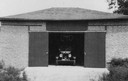
| Description: | View of a car in the open doorway of a barn at the Bartlett Memorial Historical Museum. |
| Date: | 1962 |
|---|---|
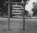
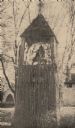
| Description: | Entrance marker to the museum. |
| Date: | 1962 |
|---|---|
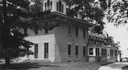
| Description: | Exterior of the museum, with a pine tree to the left, partially obstructing the building, and a path to the right. |
| Date: | 1962 |
|---|---|
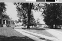
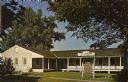
| Description: | Exterior view of the museum, with the museum annex on the left. |
| Date: | 1962 |
|---|---|
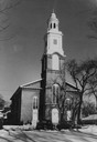
| Description: | Exterior view of First Congregational Church in winter. |
| Date: | 1962 |
|---|---|
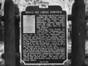
| Description: | Historical marker of the portage between the Brule and St. Croix Rivers. The marker was erected in 1962. |
| Date: | 1962 |
|---|---|
| Description: | Nashotah House, the Michael Bell. Clipping from "Oconomowoc Enterprise," November 22, 1962. More information from clipping on reverse of card. |
| Date: | 1962 |
|---|---|
| Description: | The Museum of Medical Progress at the site of Fort Crawford military hospital. |

| Date: | 1962 |
|---|---|
| Description: | A car and a trailer covered with "Gaylord Nelson for U.S. Senator" posters sits parked on a neighborhood street. |

| Date: | 1962 |
|---|---|
| Description: | During a long strike by United Packinghouse Workers Local 156, the Teamsters union attempted to lure the strikers into their union. To combat that effort, ... |

| Date: | 1962 |
|---|---|
| Description: | Robert Kennedy, then attorney general, surrounded by young people during a visit to Hong Kong. Kennedy was traveling in Southeast Asia, and the tall white-... |

| Date: | 1962 |
|---|---|
| Description: | View across road towards loading dock of the Kingsbury Brewing Company. Printed on the side of the building are two advertisements for Kingsbury Beer. |

| Date: | 1962 |
|---|---|
| Description: | A map showing the location of Indian settlements in Wisconsin, indicating the settlements of the Chippewa, or Ojibwe, at St. Croix, Lac Courte Oreilles, Re... |

| Date: | 1962 |
|---|---|
| Description: | This map shows streets, points of interest, Lake Winnebago, Millers Bay, South Asylum Bay, Lake Butte des Morts, and the Fox River. The map also includes a... |

| Date: | 1962 |
|---|---|
| Description: | This map shows streets, points of interest, Lake Winnebago, Millers Bay, South Asylum Bay, Lake Butte des Morts, and the Fox River. The map also includes a... |

| Date: | 1962 |
|---|---|
| Description: | This blue print map shows 5 zoning districts, as well as lot and block numbers and dimensions, public land, streets, and Mill Pond. The zones are: "Single ... |

| Date: | 1962 |
|---|---|
| Description: | Lewis Arms (fourth from right) waiting with other soldiers to leave for Fort McCoy. |
If you didn't find the material you searched for, our Library Reference Staff can help.
Call our reference desk at 608-264-6535 or email us at: