 Filter: Categories of Wisconsin Historical Images
Filter: FULL_DATE of 1961
Filter: Subject of streets
Filter: Categories of Wisconsin Historical Images
Filter: FULL_DATE of 1961
Filter: Subject of streets
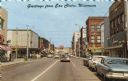
| Date: | 1961 |
|---|---|
| Description: | View down street of the downtown business district, including Woolworth's (left side) and Actor's Rexall Drug Store (right side). Caption reads: "Greetings... |

| Date: | 1961 |
|---|---|
| Description: | A mail carrier leans out the side of a Scout 80 mail truck to hand letters to children waiting at a mailbox. |
| Date: | 1961 |
|---|---|
| Description: | Aerial view of the Miller Electic Manufacturing Co. and surrounding area. |

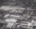
| Date: | 1961 |
|---|---|
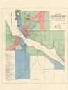
| Description: | Map of the Town of Preble, Brown County, Wisconsin, showing land ownership by name, subdivisions, roads and streets, railroads, and local businesses. |
| Date: | 1961 |
|---|---|
| Description: | Exterior of a hotel, with bright metal siding in full sunlight. An elderly man is seated in a chair outside. Behind the hotel on the left is what appears t... |

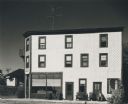
| Date: | 1961 |
|---|---|
| Description: | This map shows established harbor lines, local streets, railroads, U.S. government channel, and part of Fox River. The map includes a table of reference po... |

| Date: | 1961 |
|---|---|
| Description: | This map shows streets and some points of interest. Kewaunee River and Lake Michigan are both labeled. |
| Date: | 1961 |
|---|---|
| Description: | This map shows a sewage treatment plant site and includes an index of "Title and Index," "Watermain Details," "Sanitary Sewer Details," and "Plan B Profile... |

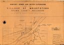
| Date: | 1961 |
|---|---|
| Description: | View from front of woman driving a yellow Scout with white topper. There is a young boy in the passenger seat. A grill and tow hook are attached to the fro... |

| Date: | 1961 |
|---|---|
| Description: | This is a photocopy of a map in blue line print that shows streets and places of interest. Inscribed in pen, at the bottom of the map, reads: "Sen. Zaborsk... |
| Date: | 1961 |
|---|---|
| Description: | This map shows platted and proposed streets, streets to be widened, proposed pedestrian paths, lot and block numbers, city wards, public buildings, and par... |

| Date: | 1961 |
|---|---|
| Description: | This map shows wards as well as proposed future streets, lot and block numbers, additions, and some landownership. The Sheboygan River is labeled. |
| Date: | 1961 |
|---|---|
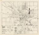
| Description: | This map shows zoning districts, wards, and house number system and is indexed for points of interest. The upper right corner includes a color coded zoning... |

| Date: | 1961 |
|---|---|
| Description: | This street map includes an ancillary map of Dane County highways and a business directory. Lake Mendota, Lake Monona, Monona Bay, Yahara River, and Lake W... |

| Date: | 1961 |
|---|---|
| Description: | A group of friends relaxing together on Williamson Street. A woman is leaning against a Volkswagon Beetle automobile with a guitar strapped over her should... |
If you didn't find the material you searched for, our Library Reference Staff can help.
Call our reference desk at 608-264-6535 or email us at: