 Filter: Categories of Wisconsin Historical Images
Filter: FULL_DATE of 1961
Filter: Subject of rivers
Filter: Categories of Wisconsin Historical Images
Filter: FULL_DATE of 1961
Filter: Subject of rivers

| Date: | 1961 |
|---|---|
| Description: | View of building under construction from a boat on the river. |

| Date: | 1961 |
|---|---|
| Description: | Sigurd Olson and friends canoeing on the Lower Churchill River. |

| Date: | 1961 |
|---|---|
| Description: | This map shows established harbor lines, local streets, railroads, U.S. government channel, and part of Fox River. The map includes a table of reference po... |

| Date: | 1961 |
|---|---|
| Description: | This map shows streets and some points of interest. Kewaunee River and Lake Michigan are both labeled. |
| Date: | 1961 |
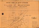
|---|---|
| Description: | This map shows a sewage treatment plant site and includes an index of "Title and Index," "Watermain Details," "Sanitary Sewer Details," and "Plan B Profile... |

| Date: | 1961 |
|---|---|
| Description: | Slightly elevated three-quarter view from front of driver's side of Scout. The Scout has a large truck bed topper that rises higher than the cab roof. A ma... |

| Date: | 1961 |
|---|---|
| Description: | This map shows wards as well as proposed future streets, lot and block numbers, additions, and some landownership. The Sheboygan River is labeled. |

| Date: | 1961 |
|---|---|
| Description: | This street map includes an ancillary map of Dane County highways and a business directory. Lake Mendota, Lake Monona, Monona Bay, Yahara River, and Lake W... |
| Date: | 1961 |
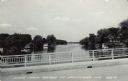
|---|---|
| Description: | View of the Rock River from a bridge at Hustisford. The river is lined with boathouses. Caption reads: "Scene from Bridge at Hustisford, Wis." |

| Date: | 1961 |
|---|---|
| Description: | People ice fishing on the frozen Mississippi River. Hills can be seen on the shoreline in the background. |
If you didn't find the material you searched for, our Library Reference Staff can help.
Call our reference desk at 608-264-6535 or email us at: