Filter: Categories of Wisconsin Historical Images
Filter: FULL_DATE of 1960
Filter: Year of 1900-1999
Filter: Subject of lakes
Filter: Categories of Wisconsin Historical Images
Filter: FULL_DATE of 1960
Filter: Year of 1900-1999
Filter: Subject of lakes
| Date: | 1960 |
|---|---|
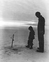
| Description: | Man and boy in silhouette ice fishing on Lake Winnebago. |

| Date: | 1960 |
|---|---|
| Description: | Cover for the 1960 Wisconsin Friends of Our Native Landscape program. Depicted are some vibrant purple flowers, with a lake in the background. The Wisconsi... |
| Date: | 1960 |
|---|---|
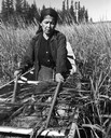
| Description: | An Ojibwa woman, Francis Mike, harvesting wild rice in a boat on Totogatic Lake. |

| Date: | 1960 |
|---|---|
| Description: | Aerial view of the construction of the interstate highway near Mirror Lake, showing only the early stages of the bridge construction. |

| Date: | 1960 |
|---|---|
| Description: | View of Ennis Lake, also known as Fountain Lake, located in the John Muir Memorial Park near Montello. As a boy, John Muir lived with his family on the sho... |

| Date: | 1960 |
|---|---|
| Description: | View of Ennis Lake, also known as Fountain Lake, located in the John Muir Memorial Park near Montello. As a boy, John Muir lived with his family on the sho... |

| Date: | 1960 |
|---|---|
| Description: | View of a state office building, and, at far right, the City-County building. |
| Date: | 1960 |
|---|---|
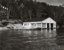
| Description: | Wet boathouse that belonged to Don Walkins, on Catfish Lake. A woman stands on a pier near a boat. |

| Date: | 1960 |
|---|---|
| Description: | View across water towards the kiddie train at Vilas Park Zoo (Henry Vilas Zoo). The train was donated by the Madison Lions Club and operated from 1953-1968... |

| Date: | 1960 |
|---|---|
| Description: | The "Pere Marquette" cargo boat, enroute from Manitowoc to Luddington. |

| Date: | 1960 |
|---|---|
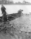
| Description: | A group of men on a shoreline pulling a fish net from a lake. Several other men watch nearby. Two men use cameras to record the event. |

| Date: | 1960 |
|---|---|
| Description: | This mid-20th century tourist brochure for Bayfield County, Wisconsin, includes a map of the county showing towns, cities and villages, highways and roads,... |

| Date: | 1960 |
|---|---|
| Description: | This map shows lot and block numbers, additions, and rural acreages and includes an index of rail roads, industrial plants, Dunn County and Menominee owned... |

| Date: | 1960 |
|---|---|
| Description: | Chrome color postcard of the boat launch area. Text on back reads: "Forest County Veteran's Memorial Park located 3 miles from Crandon, WI on the south sho... |

| Date: | 1960 |
|---|---|
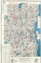
| Description: | This map shows block numbers, tract numbers, tract boundaries, city limits, local streets, railroads, Lake Mendota, and Lake Monona. |
| Date: | 1960 |
|---|---|
| Description: | This map shows lakes arranged by county, depth maps of selected larger lakes, and enlargements of Mississippi River areas. The map also includes locations ... |

| Date: | 1960 |
|---|---|
| Description: | This map shows public boat ramps, parks, highways, beaches, bluffs, Green Bay, Garrett Bay, Europe Bay and Lake, Rowley's Bay and Ellison Bay. The map incl... |

| Date: | 1960 |
|---|---|
| Description: | This map shows uplands and swamps owned by the Goodman Lumber Division, water, and roads. The lower right corner includes a location map. The upper left co... |

| Date: | 1960 |
|---|---|
| Description: | This pictorial map shows recreation activities, rivers, lakes, and the history of the area. The map covers Langlade County and parts of adjacent counties. ... |
If you didn't find the material you searched for, our Library Reference Staff can help.
Call our reference desk at 608-264-6535 or email us at: