 Filter: Categories of Wisconsin Historical Images
Filter: FULL_DATE of 1960
Filter: Year of 1900-1999
Filter: Reproduction Rights of For Sale
Filter: County of Door
Filter: Categories of Wisconsin Historical Images
Filter: FULL_DATE of 1960
Filter: Year of 1900-1999
Filter: Reproduction Rights of For Sale
Filter: County of Door
| Date: | 1960 |
|---|---|
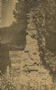
| Description: | Cottage built by Marie Gatter beginning in the 1920s along the shore road in the park. It was razed in the winter of 1960-61. The chimney was originally pa... |
| Date: | 1960 |
|---|---|
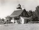
| Description: | A view of the Eagle Harbor Lighthouse. |
| Date: | 1960 |
|---|---|
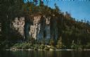
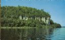
| Description: | View across water towards the 180-foot high Eagle Bluff. The bluff received its name from the eagles which formerly nested there. |
| Date: | 1960 |
|---|---|
| Description: | View across water towards the 180-foot high Eagle Bluff. The bluff received its name from the eagles which formerly nested there. |

| Date: | 1960 |
|---|---|
| Description: | View across water towards a man, woman, and two children standing on the rock ledge at Cave Point. Lake Michigan is on the right. |
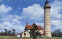
| Date: | 1960 |
|---|---|
| Description: | Color photographic postcard view of the Cana Island U.S. Lighthouse surrounded by a green lawn. There is a hand pump near the building. |

| Date: | 1960 |
|---|---|
| Description: | This map shows public boat ramps, parks, highways, beaches, bluffs, Green Bay, Garrett Bay, Europe Bay and Lake, Rowley's Bay and Ellison Bay. The map incl... |
If you didn't find the material you searched for, our Library Reference Staff can help.
Call our reference desk at 608-264-6535 or email us at: