Filter: Categories of Wisconsin Historical Images
Filter: FULL_DATE of 1960
Filter: Subject of water
Filter: Categories of Wisconsin Historical Images
Filter: FULL_DATE of 1960
Filter: Subject of water

| Date: | 1960 |
|---|---|
| Description: | View of a state office building, and, at far right, the City-County building. |
| Date: | 1960 |
|---|---|
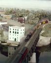
| Description: | S-1 freight meets circus train at the Dells Minirama. DBC, Steamboat Winnebago, powerhouse. |
| Date: | 1960 |
|---|---|
| Description: | Steamboat Hiawatha meeting circus train at the Dells minirama (miniature model), bridge, DBC steamboat and launch. |
| Date: | 1960 |
|---|---|
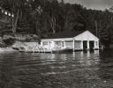
| Description: | Wet boathouse that belonged to Don Walkins, on Catfish Lake. A woman stands on a pier near a boat. |
| Date: | 1960 |
|---|---|
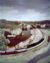
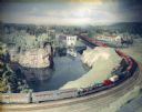
| Description: | A Wisconsin Dells minirama miniature model showing a short train with a Prairie-type locomotive on the bridge over the Wisconsin River. |
| Date: | 1960 |
|---|---|
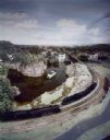
| Description: | Wisconsin Dells Minirama (miniature model) featuring a circus train on a bridge. |

| Date: | 1960 |
|---|---|
| Description: | View across water towards the kiddie train at Vilas Park Zoo (Henry Vilas Zoo). The train was donated by the Madison Lions Club and operated from 1953-1968... |

| Date: | 1960 |
|---|---|
| Description: | The "Pere Marquette" cargo boat, enroute from Manitowoc to Luddington. |

| Date: | 1960 |
|---|---|
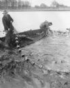
| Description: | A group of men on a shoreline pulling a fish net from a lake. Several other men watch nearby. Two men use cameras to record the event. |

| Date: | 1960 |
|---|---|
| Description: | This mid-20th century tourist brochure for Bayfield County, Wisconsin, includes a map of the county showing towns, cities and villages, highways and roads,... |

| Date: | 1960 |
|---|---|
| Description: | This manuscript map of Taylor County, Wisconsin, shows the township and range grid, lakes and streams, "Chippewa trails, Indian trails" Indian villages and... |

| Date: | 1960 |
|---|---|
| Description: | Color coded map in pink, yellow, blue, and brown of Milwaukee County State and County trunk highways. The map includes a legend of symbols: "STEAM RAIL ROA... |

| Date: | 1960 |
|---|---|
| Description: | View of landscape at the top of Rocky Glen Road, looking over flooded fields at sunrise. |

| Date: | 1960 |
|---|---|
| Description: | This map shows a plat of the city, wards, lots, local streets, roads, railroads, buildings, parks, and part of Fox River. The map includes tables for plat ... |

| Date: | 1960 |
|---|---|
| Description: | This map shows lot and block numbers, additions, and rural acreages and includes an index of rail roads, industrial plants, Dunn County and Menominee owned... |

| Date: | 1960 |
|---|---|
| Description: | This map is a cadastral map and shows block and lot numbers and dimensions, additions, streets, railroad, and Kiel Municipal Cemetery. The bottom right mar... |

| Date: | 1960 |
|---|---|
| Description: | This map shows local streets, wards, public buildings, parks, and part of the Fox River. The land is shown in white and the water is shown in blue. The map... |

| Date: | 1960 |
|---|---|
| Description: | This map shows lot numbers and dimensions, railroad, and streets. Fall Creek and Mill Pond (now Fall Creek Pond) are labeled. The map is a blue line print. |

| Date: | 1960 |
|---|---|
| Description: | Chrome color postcard of the boat launch area. Text on back reads: "Forest County Veteran's Memorial Park located 3 miles from Crandon, WI on the south sho... |
If you didn't find the material you searched for, our Library Reference Staff can help.
Call our reference desk at 608-264-6535 or email us at: