 Filter: Categories of Wisconsin Historical Images
Filter: FULL_DATE of 1960
Filter: Subject of water
Filter: Subject of military art and science
Filter: Categories of Wisconsin Historical Images
Filter: FULL_DATE of 1960
Filter: Subject of water
Filter: Subject of military art and science

| Date: | 1960 |
|---|---|
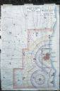
| Description: | This map is a facsimile of a 1829 map and shows private land claims, landowners within military reserve boundaries, sawmill, Fort Howard, public barns, bri... |
| Date: | 1960 |
|---|---|
| Description: | Map showing the probable blast radius of a 20 megaton bomb on Milwaukee. The map also shows existing hospitals in the area, including outside Milwaukee Cou... |
If you didn't find the material you searched for, our Library Reference Staff can help.
Call our reference desk at 608-264-6535 or email us at: