 Filter: Categories of Wisconsin Historical Images
Filter: FULL_DATE of 1960
Filter: Subject of transportation
Filter: Categories of Wisconsin Historical Images
Filter: FULL_DATE of 1960
Filter: Subject of transportation
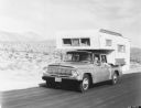
| Date: | 1960 |
|---|---|
| Description: | Man, woman, and a young child holding a pinwheel outside the window, are riding in an International 1966 Travelette pickup with camper attached. They are t... |

| Date: | 1960 |
|---|---|
| Description: | Group of men posing indoors near a roped-off display of an engine. In the background is an International Truck. |

| Date: | 1960 |
|---|---|
| Description: | View from across road of the International Harvester Farm and Industrial Equipment building. |

| Date: | 1960 |
|---|---|
| Description: | This street map was likely given out by Mound City Bank and features a legend of points of interest and a street index. Streets are labeled as is the Round... |

| Date: | 1960 |
|---|---|
| Description: | Aerial view of the Trees for Tomorrow Environmental Center, with buildings, grounds, roads, and the Eagle River. Founded in 1944. |

| Date: | 1960 |
|---|---|
| Description: | View across sidewalk and street towards the First Congregational Church, located at the corner of First and Division Streets. Built in 1924. |
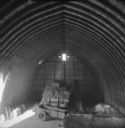
| Date: | 1960 |
|---|---|
| Description: | Elevated view from hayloft of the barn, with a wagon full of hay bales, an empty wagon, and a conveyer sitting in the center of the loft. |

| Date: | 1960 |
|---|---|
| Description: | This map shows block numbers, tract numbers, tract boundaries, city limits, local streets, railroads, Lake Mendota, and Lake Monona. |

| Date: | 1960 |
|---|---|
| Description: | This blue print map shows village limits, collector residential streets, and primary residential streets. The upper right corner features a key to street t... |

| Date: | 1960 |
|---|---|
| Description: | This blue line print shows state and city maintained roads, as well as government land, parks, Milwaukee Co. Park Commission, golf courses, schools, City o... |

| Date: | 1960 |
|---|---|
| Description: | This blue line print map shows pipes, valves, well site, and elevation tank, as well as lot and block numbers and dimensions. The map includes inset of con... |
| Date: | 1960 |
|---|---|
| Description: | This blue line print map shows lot and block numbers and dimensions, some landownership, roads, and railroads. The map includes manuscript annotations of a... |

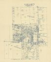
| Date: | 1960 |
|---|---|
| Description: | This map includes a sheet index showing streets, proposed streets, the high school, and railroad. |
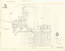
| Date: | 1960 |
|---|---|
| Description: | This map shows water mains, valves, hydrants, crosses, tees, and elevated tanks. The back of the map reads: "Notice of public hearing from T.H. Schuette, v... |

| Date: | 1960 |
|---|---|
| Description: | This blue line print map shows zone districts, lot and block numbers and dimensions, building setbacks, center lines of streets, and some landownership. Th... |

| Date: | 1960 |
|---|---|
| Description: | A man stands in the foreground on the left with arm raised while a Bucyrus-Erie power shovel dumps a load into a Model 65 Payhauler. Off road rock truck. T... |

| Date: | 1960 |
|---|---|
| Description: | Right side view of a Model 65 Payhauler outdoors. A Bucyrus-Erie power shovel is dumping dirt and rock into the dump truck. The Model 65 is the smallest of... |

| Date: | 1960 |
|---|---|
| Description: | This dot density map shows the number of shipments in 1952 throughout Wisconsin and to other United States destinations from Neillsville. Mellen, Cable, Bl... |

| Date: | 1960 |
|---|---|
| Description: | This dot density map shows tickets sold in 1913, by destination, from Birchwood, Wisconsin. Several communities are labeled. The bottom right corner has a ... |

| Date: | 1960 |
|---|---|
| Description: | This map shows public boat ramps, parks, highways, beaches, bluffs, Green Bay, Garrett Bay, Europe Bay and Lake, Rowley's Bay and Ellison Bay. The map incl... |
If you didn't find the material you searched for, our Library Reference Staff can help.
Call our reference desk at 608-264-6535 or email us at: