 Filter: Categories of Wisconsin Historical Images
Filter: FULL_DATE of 1960
Filter: Subject of streets
Filter: Subject of parks
Filter: Categories of Wisconsin Historical Images
Filter: FULL_DATE of 1960
Filter: Subject of streets
Filter: Subject of parks

| Date: | 1960 |
|---|---|
| Description: | This map of Greedale shows local streets, parks, schools, and churches and includes manuscript annotations in green and blue showing tracts and parcels of ... |
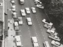
| Date: | 1960 |
|---|---|
| Description: | View looking down on Pinckney Street, with a section of Capitol park, from the Belmont Hotel. |

| Date: | 1960 |
|---|---|
| Description: | This map shows a plat of the city, wards, lots, local streets, roads, railroads, buildings, parks, and part of Fox River. The map includes tables for plat ... |

| Date: | 1960 |
|---|---|
| Description: | This map shows lot and block numbers, additions, and rural acreages and includes an index of rail roads, industrial plants, Dunn County and Menominee owned... |

| Date: | 1960 |
|---|---|
| Description: | This map shows local streets, wards, public buildings, parks, and part of the Fox River. The land is shown in white and the water is shown in blue. The map... |

| Date: | 1960 |
|---|---|
| Description: | This blue line print shows state and city maintained roads, as well as government land, parks, Milwaukee Co. Park Commission, golf courses, schools, City o... |

| Date: | 1960 |
|---|---|
| Description: | Air view focused on the Greenbush neighborhood of Madison prior to its demolition for the Triangle Redevelopment Project. Monona Bay and Brittingham Park a... |
If you didn't find the material you searched for, our Library Reference Staff can help.
Call our reference desk at 608-264-6535 or email us at: