Filter: Categories of Wisconsin Historical Images
Filter: FULL_DATE of 1960
Filter: Subject of outdoor photography
Filter: Categories of Wisconsin Historical Images
Filter: FULL_DATE of 1960
Filter: Subject of outdoor photography

| Date: | 1960 |
|---|---|
| Description: | View down slope across open fields over a barbed wire fence towards the horizon. The field is uncut in the foreground, obscuring an abandoned farm implemen... |
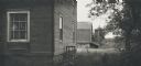
| Date: | 1960 |
|---|---|
| Description: | New residential construction on the outer southwest edge of Madison. |

| Date: | 1960 |
|---|---|
| Description: | Hardwood growth in the Madison School Forest. |

| Date: | 1960 |
|---|---|
| Description: | Flowering bush on Rocky Dell Road. |

| Date: | 1960 |
|---|---|
| Description: | Elevated view of landscape, with large dead birch tree, looking south east near the junction of Highways 19 and 78. |

| Date: | 1960 |
|---|---|
| Description: | Large pasture valley between Black Earth and Marxville, at sunset. |

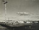
| Date: | 1960 |
|---|---|
| Description: | Evening view of the Westgate Shopping Center reflected in Montgomery Ward store window at the time of opening, while the center was still partially under c... |

| Date: | 1960 |
|---|---|
| Description: | View looking down on Pinckney Street, with a section of Capitol park, from the Belmont Hotel. |

| Date: | 1960 |
|---|---|
| Description: | View of landscape at the top of Rocky Glen Road, looking over flooded fields at sunrise. |

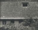
| Date: | 1960 |
|---|---|
| Description: | Frame residence with horseshoe arched front window. The tree in the foreground has blossoms on the branches. |
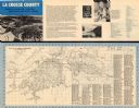
| Date: | 1960 |
|---|---|
| Description: | This map is oriented with north to the right and includes an index of streets. The back of the map features text about La Crosse. |
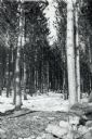
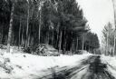
| Date: | 1960 |
|---|---|
| Description: | Tall trees in a snowy forest on a sunny day. |
| Date: | 1960 |
|---|---|
| Description: | Several men are working with logs and equipment in Brule River State Forest. |
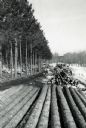
| Date: | 1960 |
|---|---|
| Description: | Several piles of logs along a logging road waiting for truck pick up. |

| Date: | 1960 |
|---|---|
| Description: | Chrome color postcard of the boat launch area. Text on back reads: "Forest County Veteran's Memorial Park located 3 miles from Crandon, WI on the south sho... |
If you didn't find the material you searched for, our Library Reference Staff can help.
Call our reference desk at 608-264-6535 or email us at: