Filter: Categories of Wisconsin Historical Images
Filter: FULL_DATE of 1960
Filter: Subject of michigan, lake
Filter: Categories of Wisconsin Historical Images
Filter: FULL_DATE of 1960
Filter: Subject of michigan, lake
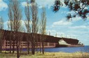
| Date: | 1960 |
|---|---|
| Description: | The screw bulk freighter, Wilfred Sykes at L.S. and I. Ore Dock in Marquette, Michigan about 1960. Lake shore and trees are in the foreground. |
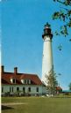
| Date: | 1960 |
|---|---|
| Description: | A view of the Eagle Harbor Lighthouse. |
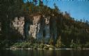
| Date: | 1960 |
|---|---|
| Description: | View across water towards the 180-foot high Eagle Bluff. The bluff received its name from the eagles which formerly nested there. |

| Date: | 1960 |
|---|---|
| Description: | View across water towards the 180-foot high Eagle Bluff. The bluff received its name from the eagles which formerly nested there. |

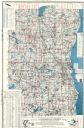
| Date: | 1960 |
|---|---|
| Description: | Color coded map in pink, yellow, blue, and brown of Milwaukee County State and County trunk highways. The map includes a legend of symbols: "STEAM RAIL ROA... |

| Date: | 1960 |
|---|---|
| Description: | View across water towards a man, woman, and two children standing on the rock ledge at Cave Point. Lake Michigan is on the right. |
| Date: | 1960 |
|---|---|
| Description: | This map shows lakes arranged by county, depth maps of selected larger lakes, and enlargements of Mississippi River areas. The map also includes locations ... |
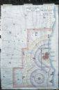
| Date: | 1960 |
|---|---|
| Description: | Map showing the probable blast radius of a 20 megaton bomb on Milwaukee. The map also shows existing hospitals in the area, including outside Milwaukee Cou... |
If you didn't find the material you searched for, our Library Reference Staff can help.
Call our reference desk at 608-264-6535 or email us at: