Filter: Categories of Wisconsin Historical Images
Filter: FULL_DATE of 1960
Filter: Subject of land
Filter: Categories of Wisconsin Historical Images
Filter: FULL_DATE of 1960
Filter: Subject of land
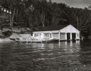
| Date: | 1960 |
|---|---|
| Description: | Wet boathouse that belonged to Don Walkins, on Catfish Lake. A woman stands on a pier near a boat. |
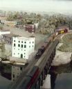
| Date: | 1960 |
|---|---|
| Description: | A Wisconsin Dells minirama miniature model showing a short train with a Prairie-type locomotive on the bridge over the Wisconsin River. |
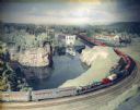
| Date: | 1960 |
|---|---|
| Description: | Wisconsin Dells Minirama (miniature model) featuring a circus train on a bridge. |

| Date: | 1960 |
|---|---|
| Description: | An original lithograph distributed by the Soo Line Railway Company, as a promotion for their shipping and passenger services. The poster features a train t... |
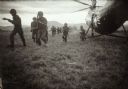
| Date: | 1960 |
|---|---|
| Description: | Marines running out of a helicopter in Vietnam. |
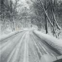
| Date: | 1960 |
|---|---|
| Description: | A winter scene down a road in the snow-covered arboretum. |

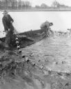
| Date: | 1960 |
|---|---|
| Description: | A group of men on a shoreline pulling a fish net from a lake. Several other men watch nearby. Two men use cameras to record the event. |

| Date: | 1960 |
|---|---|
| Description: | This mid-20th century tourist brochure for Bayfield County, Wisconsin, includes a map of the county showing towns, cities and villages, highways and roads,... |

| Date: | 1960 |
|---|---|
| Description: | A hand-drawn map showing the "Negro Percentage of Each County's Population" in Mississippi. |

| Date: | 1960 |
|---|---|
| Description: | Flowering bush on Rocky Dell Road. |

| Date: | 1960 |
|---|---|
| Description: | This map of Greedale shows local streets, parks, schools, and churches and includes manuscript annotations in green and blue showing tracts and parcels of ... |

| Date: | 1960 |
|---|---|
| Description: | Elevated view of landscape, with large dead birch tree, looking south east near the junction of Highways 19 and 78. |

| Date: | 1960 |
|---|---|
| Description: | Large pasture valley between Black Earth and Marxville, at sunset. |
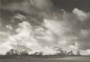
| Date: | 1960 |
|---|---|
| Description: | Large field and trees, with spectacular driven clouds. |

| Date: | 1960 |
|---|---|
| Description: | View of landscape at the top of Rocky Glen Road, looking over flooded fields at sunrise. |

| Date: | 1960 |
|---|---|
| Description: | This map shows a plat of the city, wards, lots, local streets, roads, railroads, buildings, parks, and part of Fox River. The map includes tables for plat ... |

| Date: | 1960 |
|---|---|
| Description: | This map shows lot and block numbers, additions, and rural acreages and includes an index of rail roads, industrial plants, Dunn County and Menominee owned... |
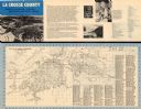
| Date: | 1960 |
|---|---|
| Description: | This map is oriented with north to the right and includes an index of streets. The back of the map features text about La Crosse. |
If you didn't find the material you searched for, our Library Reference Staff can help.
Call our reference desk at 608-264-6535 or email us at: