Filter: Categories of Wisconsin Historical Images
Filter: FULL_DATE of 1960
Filter: Subject of land
Filter: Subject of trees
Filter: Categories of Wisconsin Historical Images
Filter: FULL_DATE of 1960
Filter: Subject of land
Filter: Subject of trees
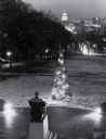
| Date: | 1960 |
|---|---|
| Description: | Elevated view looking east from Lincoln Terrace on Bascom Hill on the University of Wisconsin-Madison campus. The Lincoln Monument is in the foreground and... |
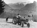
| Date: | 1960 |
|---|---|
| Description: | German farmers pulling a wooden log with a McCormick D-435 tractor against a mountainous backdrop in Alpine country. |
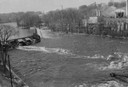
| Date: | 1960 |
|---|---|
| Description: | Elevated view looking down at the Fox River. On the left is a dam, and on the opposite shoreline is a factory. |

| Date: | 1960 |
|---|---|
| Description: | Aerial view with docks in the foreground. Caption reads: "Superior, Wisconsin." |
| Date: | 1960 |
|---|---|
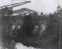
| Description: | Excavation for bridge column footings for the Mirror Lake Bridge. |
| Date: | 1960 |
|---|---|
| Description: | View from below looking up towards workers constructing and reinforcing the forms for the footings of the interstate highway bridge at Mirror Lake. |

| Date: | 1960 |
|---|---|
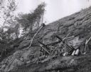
| Description: | Aerial view of the construction of the interstate highway near Mirror Lake, showing only the early stages of the bridge construction. |

| Date: | 1960 |
|---|---|
| Description: | View of Ennis Lake, also known as Fountain Lake, located in the John Muir Memorial Park near Montello. As a boy, John Muir lived with his family on the sho... |

| Date: | 1960 |
|---|---|
| Description: | View of Ennis Lake, also known as Fountain Lake, located in the John Muir Memorial Park near Montello. As a boy, John Muir lived with his family on the sho... |
| Date: | 1960 |
|---|---|
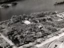
| Description: | Aerial view of Villa Louis on the Mississippi River, and adjacent buildings. |
| Date: | 1960 |
|---|---|
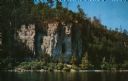
| Description: | View across water towards the 180-foot high Eagle Bluff. The bluff received its name from the eagles which formerly nested there. |
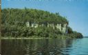
| Date: | 1960 |
|---|---|
| Description: | View across water towards the 180-foot high Eagle Bluff. The bluff received its name from the eagles which formerly nested there. |

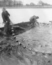
| Date: | 1960 |
|---|---|
| Description: | A group of men on a shoreline pulling a fish net from a lake. Several other men watch nearby. Two men use cameras to record the event. |

| Date: | 1960 |
|---|---|
| Description: | Elevated view of landscape, with large dead birch tree, looking south east near the junction of Highways 19 and 78. |

| Date: | 1960 |
|---|---|
| Description: | Large pasture valley between Black Earth and Marxville, at sunset. |
| Date: | 1960 |
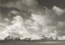
|---|---|
| Description: | Large field and trees, with spectacular driven clouds. |

| Date: | 1960 |
|---|---|
| Description: | View of landscape at the top of Rocky Glen Road, looking over flooded fields at sunrise. |

| Date: | 1960 |
|---|---|
| Description: | View across water towards a man, woman, and two children standing on the rock ledge at Cave Point. Lake Michigan is on the right. |
If you didn't find the material you searched for, our Library Reference Staff can help.
Call our reference desk at 608-264-6535 or email us at: