Filter: Categories of Wisconsin Historical Images
Filter: FULL_DATE of 1960
Filter: Subject of human settlements
Filter: Categories of Wisconsin Historical Images
Filter: FULL_DATE of 1960
Filter: Subject of human settlements
| Date: | 1960 |
|---|---|
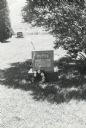
| Description: | Walter and Ionie Arms's grave marker in the shade of a tall bush at the Burr Ridge cemetery. |

| Date: | 1960 |
|---|---|
| Description: | Lewis Arms sits on a military tank at the Park Street United States Army Reserve Center. |

| Date: | 1960 |
|---|---|
| Description: | Lewis Arms poses in front of a military tank wearing army gear. On the tank from left to right are Lew Arms, Jr., Craig Arms, Rita Arms, and Mamie Arms. |

| Date: | 1960 |
|---|---|
| Description: | Three men pose together on a picket line at the Case plant. The man in the center holds a sign reading: "Case Local demands justice." The Case eagle on a g... |
| Date: | 1960 |
|---|---|
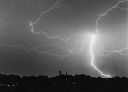
| Description: | "Spectacular lightning lights up the sky on a summer evening." |
| Date: | 1960 |
|---|---|
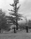
| Description: | The entrance gate to Howes Corners Cemetery on Beechnut Avenue. The large tree in the center has a downed limb which has fallen over some of the graves. |
| Date: | 1960 |
|---|---|
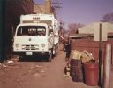
| Description: | Color photo of a man collecting garbage cans from an alleyway and emptying them into a truck with an IH logo on the front of the chassis and a Leach logo o... |

| Date: | 1960 |
|---|---|
| Description: | This mid-20th century tourist brochure for Bayfield County, Wisconsin, includes a map of the county showing towns, cities and villages, highways and roads,... |

| Date: | 1960 |
|---|---|
| Description: | Color coded map in pink, yellow, blue, and brown of Milwaukee County State and County trunk highways. The map includes a legend of symbols: "STEAM RAIL ROA... |
| Date: | 1960 |
|---|---|
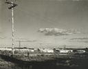
| Description: | New residential construction on the outer southwest edge of Madison. |

| Date: | 1960 |
|---|---|
| Description: | This map of Greedale shows local streets, parks, schools, and churches and includes manuscript annotations in green and blue showing tracts and parcels of ... |
| Date: | 1960 |
|---|---|
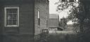
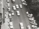
| Description: | View looking down on Pinckney Street, with a section of Capitol park, from the Belmont Hotel. |

| Date: | 1960 |
|---|---|
| Description: | This map shows a plat of the city, wards, lots, local streets, roads, railroads, buildings, parks, and part of Fox River. The map includes tables for plat ... |

| Date: | 1960 |
|---|---|
| Description: | This map shows lot and block numbers, additions, and rural acreages and includes an index of rail roads, industrial plants, Dunn County and Menominee owned... |

| Date: | 1960 |
|---|---|
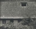
| Description: | Frame residence with horseshoe arched front window. The tree in the foreground has blossoms on the branches. |
| Date: | 1960 |
|---|---|
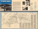
| Description: | This map is oriented with north to the right and includes an index of streets. The back of the map features text about La Crosse. |

| Date: | 1960 |
|---|---|
| Description: | This map is a cadastral map and shows block and lot numbers and dimensions, additions, streets, railroad, and Kiel Municipal Cemetery. The bottom right mar... |
If you didn't find the material you searched for, our Library Reference Staff can help.
Call our reference desk at 608-264-6535 or email us at: