 Filter: Categories of Wisconsin Historical Images
Filter: FULL_DATE of 1960
Filter: Subject of human settlements
Filter: Categories of Wisconsin Historical Images
Filter: FULL_DATE of 1960
Filter: Subject of human settlements

| Date: | 1960 |
|---|---|
| Description: | This map shows U.S. highways, state highways, county highways, town roads, county parks, county highway buildings, waysides, rivers, lakes, airports, a civ... |

| Date: | 1960 |
|---|---|
| Description: | View across field towards the Sacred Heart Hospital at 900 W. Clairemont Avenue, (Hwy 12 at Jct. 37 & 85). |

| Date: | 1960 |
|---|---|
| Description: | This colored road map shows roads in Wisconsin as well as portions of nearby states. Information on the quality and type of any road shown can be found in ... |

| Date: | 1960 |
|---|---|
| Description: | Aerial view of rural landscape with suburban construction in foreground. Cottage Grove Road is at left with the newly constructed Acewood Boulevard crossin... |

| Date: | 1960 |
|---|---|
| Description: | The State Historical Society of Wisconsin building and grounds after a snowstorm. State Street is on the far left, with Bascom Hill in the background. |
| Date: | 1960 |
|---|---|
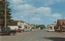
| Description: | View down street towards automobiles parked at an angle in front of businesses. Businesses include a grocery store, gift store, and a Rexall Drugstore. Fur... |
| Date: | 1960 |
|---|---|
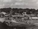
| Description: | Elevated view from hill looking north, showing the grounds of the Circus World historic site, with visiting crowd. On display are several train cars and wa... |
| Date: | 1960 |
|---|---|
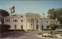
| Description: | Exterior view from driveway of the Governor's Mansion in Maple Bluff. Flags are flying from a flagpole in the yard on the left. Columns frame the front ent... |
| Date: | 1960 |
|---|---|
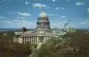
| Description: | Elevated view of the Capitol's West Washington entrance. Lake Monona is on the right, and Lake Mendota is on the left. |

| Date: | 1960 |
|---|---|
| Description: | Air view of the Lake Mendota Shore looking east. The Edgewater Hotel and Kennedy Manor are at bottom center with Lake Mendota at left. James Madison Park i... |

| Date: | 1960 |
|---|---|
| Description: | Air view focused on the Greenbush neighborhood of Madison prior to its demolition for the Triangle Redevelopment Project. Monona Bay and Brittingham Park a... |
| Date: | 1960 |
|---|---|
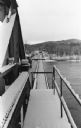
| Description: | Drawbridge over the Wisconsin River with the lift mechanism on the left. |

| Date: | 1960 |
|---|---|
| Description: | Steam and smoke billow as a man is boiling maple syrup on the Harvey Blue farm. |
| Date: | 1960 |
|---|---|
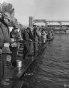
| Description: | View of a crowd of people lined up fishing side by side on long pier. A railroad bridge, with a tanker car, is in the background. |

| Date: | 1960 |
|---|---|
| Description: | A man is running his dog on a trail in an old lead mining area. The trees are bare and fallen leaves are covering the ground. |
| Date: | 1960 |
|---|---|
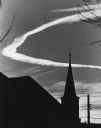
| Description: | A circular contrail forming a halo behind a silhouetted church steeple. Power lines are in the background. |

| Date: | 1960 |
|---|---|
| Description: | Aerial view of Indianapolis Motor Truck Engine Works. |
| Date: | 1960 |
|---|---|
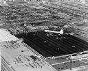
| Description: | An airplane in the foreground is flying over the complex. Caption reads: "Melrose Park Engine & Crawler Tractor Works, Melrose Park, Illinois." |

| Date: | 1960 |
|---|---|
| Description: | Aerial View of Louisville Engine & Tractor Works. |

| Date: | 1960 |
|---|---|
| Description: | Construction Equipment Division. |
If you didn't find the material you searched for, our Library Reference Staff can help.
Call our reference desk at 608-264-6535 or email us at: