 Filter: Categories of Wisconsin Historical Images
Filter: FULL_DATE of 1960
Filter: Subject of education
Filter: Categories of Wisconsin Historical Images
Filter: FULL_DATE of 1960
Filter: Subject of education
| Date: | 1960 |
|---|---|
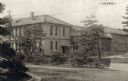
| Description: | Exterior view of the Pharmaceutical Sciences Building and grounds at Kyoto University, Japan. |
| Date: | 1960 |
|---|---|
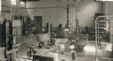
| Description: | View of pharmaceutical processing equipment in one of the laboratory classrooms at Kyoto University's Pharmaceutical Sciences building. |
| Date: | 1960 |
|---|---|
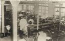
| Description: | View of students in one of the laboratory classrooms at Kyoto University's Pharmaceutical Sciences building. |
| Date: | 1960 |
|---|---|
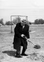
| Description: | Dr. Robert Fischelis shovels fresh dirt to break ground for the Ohio Northern University's College of Pharmacy Building. |
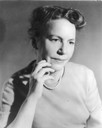
| Date: | 1960 |
|---|---|
| Description: | Quarter-length studio portrait of Professor Elizabeth Wickenden, professor of urban studies and technical consultant on public social policy to the Nationa... |
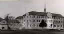
| Date: | 1960 |
|---|---|
| Description: | Campion Jesuit High School, Lawler Hall, finished in 1955. |
| Date: | 1960 |
|---|---|
| Description: | An adjunct of the Milwaukee Vocational and Adult Schools. |

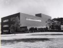
| Date: | 1960 |
|---|---|
| Description: | Interior view of the dining room at the Wisconsin Center for adult education at 702 Langdon Street, showing tables and chairs, and modern light fixtures. |

| Date: | 1960 |
|---|---|
| Description: | This mid-20th century tourist brochure for Bayfield County, Wisconsin, includes a map of the county showing towns, cities and villages, highways and roads,... |

| Date: | 1960 |
|---|---|
| Description: | This map of Greedale shows local streets, parks, schools, and churches and includes manuscript annotations in green and blue showing tracts and parcels of ... |

| Date: | 1960 |
|---|---|
| Description: | This map shows lot and block numbers, additions, and rural acreages and includes an index of rail roads, industrial plants, Dunn County and Menominee owned... |

| Date: | 1960 |
|---|---|
| Description: | This blue line print shows state and city maintained roads, as well as government land, parks, Milwaukee Co. Park Commission, golf courses, schools, City o... |

| Date: | 1960 |
|---|---|
| Description: | This map includes a sheet index showing streets, proposed streets, the high school, and railroad. |

| Date: | 1960 |
|---|---|
| Description: | Caption on back: "Lester J. Kornely, teacher of the summer school for migrant children, poses with some of the pupils enrolled from the three migrant camps... |
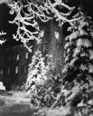
| Date: | 1960 |
|---|---|
| Description: | The clock tower at St. John's Military Academy, framed by snow-covered branches. |
| Date: | 1960 |
|---|---|
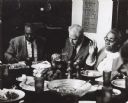
| Description: | From left to right are Esau Jackson, Morris Mitchell and Septima Clark. They are attending a dinner at Highlander Folk School. |

| Date: | 1960 |
|---|---|
| Description: | Three people stand outdoors at Highlander Folk School. From left to right are: May Justus (most likely), Kwa O. Hagen and Septima Clark. There is an Americ... |
If you didn't find the material you searched for, our Library Reference Staff can help.
Call our reference desk at 608-264-6535 or email us at: