Filter: Categories of Wisconsin Historical Images
Filter: FULL_DATE of 1960
Filter: Reproduction Rights of For Sale
Filter: Subject of parks
Filter: Categories of Wisconsin Historical Images
Filter: FULL_DATE of 1960
Filter: Reproduction Rights of For Sale
Filter: Subject of parks

| Date: | 1960 |
|---|---|
| Description: | View of Ennis Lake, also known as Fountain Lake, located in the John Muir Memorial Park near Montello. As a boy, John Muir lived with his family on the sho... |

| Date: | 1960 |
|---|---|
| Description: | View of Ennis Lake, also known as Fountain Lake, located in the John Muir Memorial Park near Montello. As a boy, John Muir lived with his family on the sho... |

| Date: | 1960 |
|---|---|
| Description: | Statue of the monk with a cross in his left hand and his right hand upraised. Behind the statue is a plaque with a carving of an Indian in a canoe near a s... |

| Date: | 1960 |
|---|---|
| Description: | Color coded map in pink, yellow, blue, and brown of Milwaukee County State and County trunk highways. The map includes a legend of symbols: "STEAM RAIL ROA... |

| Date: | 1960 |
|---|---|
| Description: | This map of Greedale shows local streets, parks, schools, and churches and includes manuscript annotations in green and blue showing tracts and parcels of ... |
| Date: | 1960 |
|---|---|
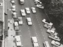
| Description: | View looking down on Pinckney Street, with a section of Capitol park, from the Belmont Hotel. |

| Date: | 1960 |
|---|---|
| Description: | This map shows a plat of the city, wards, lots, local streets, roads, railroads, buildings, parks, and part of Fox River. The map includes tables for plat ... |

| Date: | 1960 |
|---|---|
| Description: | This map shows lot and block numbers, additions, and rural acreages and includes an index of rail roads, industrial plants, Dunn County and Menominee owned... |

| Date: | 1960 |
|---|---|
| Description: | This map shows local streets, wards, public buildings, parks, and part of the Fox River. The land is shown in white and the water is shown in blue. The map... |

| Date: | 1960 |
|---|---|
| Description: | Chrome color postcard of the boat launch area. Text on back reads: "Forest County Veteran's Memorial Park located 3 miles from Crandon, WI on the south sho... |

| Date: | 1960 |
|---|---|
| Description: | View across water towards a man, woman, and two children standing on the rock ledge at Cave Point. Lake Michigan is on the right. |

| Date: | 1960 |
|---|---|
| Description: | This blue line print shows state and city maintained roads, as well as government land, parks, Milwaukee Co. Park Commission, golf courses, schools, City o... |

| Date: | 1960 |
|---|---|
| Description: | This map shows public boat ramps, parks, highways, beaches, bluffs, Green Bay, Garrett Bay, Europe Bay and Lake, Rowley's Bay and Ellison Bay. The map incl... |

| Date: | 1960 |
|---|---|
| Description: | This map shows U.S. highways, state highways, county highways, town roads, county parks, county highway buildings, waysides, rivers, lakes, airports, a civ... |

| Date: | 1960 |
|---|---|
| Description: | Air view of the Lake Mendota Shore looking east. The Edgewater Hotel and Kennedy Manor are at bottom center with Lake Mendota at left. James Madison Park i... |

| Date: | 1960 |
|---|---|
| Description: | Air view focused on the Greenbush neighborhood of Madison prior to its demolition for the Triangle Redevelopment Project. Monona Bay and Brittingham Park a... |

| Date: | 1960 |
|---|---|
| Description: | Text on front reads: "Pattison Park, Superior, Wisconsin." On reverse: "Pattison State Park. 12 Miles from Superior, Wisc. on Hiway 35. Interfalls Lake is ... |
If you didn't find the material you searched for, our Library Reference Staff can help.
Call our reference desk at 608-264-6535 or email us at: