 Filter: Categories of Wisconsin Historical Images
Filter: FULL_DATE of 1959
Filter: Subject of transportation
Filter: Subject of cities and towns
Filter: Categories of Wisconsin Historical Images
Filter: FULL_DATE of 1959
Filter: Subject of transportation
Filter: Subject of cities and towns

| Date: | 1959 |
|---|---|
| Description: | Metro trucks and Metro-Mites parked bumper to bumper in an outdoor lot at the Metropolitan Body company, an International Harvester subsidiary. The truck a... |

| Date: | 1959 |
|---|---|
| Description: | Elevated view of rows of Farmall tractors lined up in a lot outside International Harvester's Farmall Works. Original caption (with magazine article) reads... |

| Date: | 1959 |
|---|---|
| Description: | Rows of Farmall tractors stand outside International Harvester's Farmall Works. The factory site includes Industrial buildings and a water tower. |

| Date: | 1959 |
|---|---|
| Description: | This map identifies public forest land and industrial forest land as of 1959 in Oneida County, Wisconsin, using a 1930 base map showing the township and ra... |
| Date: | 1959 |
|---|---|
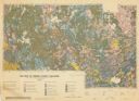
| Description: | Map of soil in Oneida County. Bottom of the map includes a legend of soil; "SECOND CLASS SOILS GOOD TO FAIR FARM LAND" are represented in shades of yellow ... |

| Date: | 1959 |
|---|---|
| Description: | Aerial view of the Westgate Shopping Center under construction. |

| Date: | 1959 |
|---|---|
| Description: | This map of Lake Geneva has relief shown by contours and water depths shown by isolines. The map includes an index of schools, churches, public services, i... |

| Date: | 1959 |
|---|---|
| Description: | This map shows wards and precincts by number, local streets, roads, parks, Shorewood Hills, Maple Bluff, Middleton, Verona, McFarland, Monona, Truax Field,... |

| Date: | 1959 |
|---|---|
| Description: | This map shows some land ownership, lot and block numbers, additions, fair grounds, streets, and railroads and is indexed. Mullet River and Mill Pond are l... |
| Date: | 1959 |
|---|---|
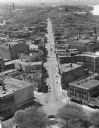
| Description: | Elevated view of State Street from the Wisconsin State Capitol building. Lake Mendota is on the far right. |

| Date: | 1959 |
|---|---|
| Description: | This map shows landownership, acreages, and old fort road on the southwest corner of Madeline Island. The map includes an explanation of survey in the midd... |

| Date: | 1959 |
|---|---|
| Description: | This map shows public access sites, public beaches and parks, other public shorelines, boat liveries, public hunting and fishing grounds, railroads, roads,... |
| Date: | 1959 |
|---|---|
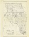
| Description: | This map shows roads, landowners, acreages, and buildings. |

| Date: | 1959 |
|---|---|
| Description: | This colored road map shows roads in Wisconsin as well as portions of nearby states. Information on the quality and type of any road shown (expressways, St... |
| Date: | 1959 |
|---|---|
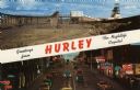
| Description: | Two views of Hurley. At the top is the Cary Mine. On the bottom is Silver Street lined with clubs and electric signs. Caption reads: "Greetings from Hurley... |

| Date: | 1959 |
|---|---|
| Description: | Text on front reads: "Sheboygan Yacht Club, Sheboygan, Wisconsin." View down concrete dock towards boats moored between wooden piers. In the background alo... |

| Date: | 1959 |
|---|---|
| Description: | Text on front reads: "St. Ann Catholic Church & School. Stoughton, Wis." A brick church and school with a 1959 Rambler Cross Country Station Wagon parked a... |

| Date: | 1959 |
|---|---|
| Description: | Text on reverse reads: "Main Street, Watertown, Wis." A busy street scene with automobiles in the street and parked along the curb. The street is lined wit... |
If you didn't find the material you searched for, our Library Reference Staff can help.
Call our reference desk at 608-264-6535 or email us at: