 Filter: Categories of Wisconsin Historical Images
Filter: FULL_DATE of 1959
Filter: Subject of transportation
Filter: Community of Madison
Filter: Categories of Wisconsin Historical Images
Filter: FULL_DATE of 1959
Filter: Subject of transportation
Filter: Community of Madison

| Date: | 1959 |
|---|---|
| Description: | Elevated view looking east from shoreline of Lake Monona towards Monona shoreline. There is a road, railroad tracks, and a rocky beach area with parked au... |
| Date: | 1959 |
|---|---|
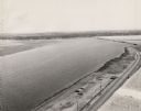
| Description: | Elevated view looking south over Lake Monona. Shoreline and automobiles in parking lot in lower right, next to a road. Railroad tracks cross the lake and b... |

| Date: | 1959 |
|---|---|
| Description: | Elevated view of dirt parking lot between a road and the lake. Steam is rising from the lake, and the far shoreline can be seen in the distance. |

| Date: | 1959 |
|---|---|
| Description: | University of Wisconsin-Madison campus. Numbers in circles identify buildings across campus with the building index. Black arrows point out important infor... |

| Date: | 1959 |
|---|---|
| Description: | Color postcard of the exterior of the Wisconsin Center for adult education at 702 Langdon Street. |

| Date: | 1959 |
|---|---|
| Description: | Aerial view of the Westgate Shopping Center under construction. |

| Date: | 1959 |
|---|---|
| Description: | This map shows wards and precincts by number, local streets, roads, parks, Shorewood Hills, Maple Bluff, Middleton, Verona, McFarland, Monona, Truax Field,... |
| Date: | 1959 |
|---|---|
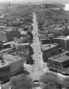
| Description: | Elevated view of State Street from the Wisconsin State Capitol building. Lake Mendota is on the far right. |
If you didn't find the material you searched for, our Library Reference Staff can help.
Call our reference desk at 608-264-6535 or email us at: