 Filter: Categories of Wisconsin Historical Images
Filter: FULL_DATE of 1959
Filter: Subject of rivers
Filter: Categories of Wisconsin Historical Images
Filter: FULL_DATE of 1959
Filter: Subject of rivers
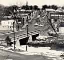
| Date: | 1959 |
|---|---|
| Description: | Elevated view of street with bridge in Darlington. Cars are parked in the center of the street at an angle. |

| Date: | 1959 |
|---|---|
| Description: | Color photo of an International truck driving beneath a bridge spanning a dam on the Colorado River. |
| Date: | 1959 |
|---|---|
| Description: | An International truck sits on a bridge spanning Glen Canyon and the Colorado River. |

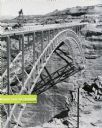
| Date: | 1959 |
|---|---|
| Description: | This map shows some land ownership, lot and block numbers, additions, fair grounds, streets, and railroads and is indexed. Mullet River and Mill Pond are l... |

| Date: | 1959 |
|---|---|
| Description: | This map shows public access sites, public beaches and parks, other public shorelines, boat liveries, public hunting and fishing grounds, railroads, roads,... |

| Date: | 1959 |
|---|---|
| Description: | This colored road map shows roads in Wisconsin as well as portions of nearby states. Information on the quality and type of any road shown (expressways, St... |
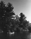
| Date: | 1959 |
|---|---|
| Description: | Paddlers in a canoe on their way down the Namekagon river. The shoreline on the left is tree-covered. |
If you didn't find the material you searched for, our Library Reference Staff can help.
Call our reference desk at 608-264-6535 or email us at: