 Filter: Categories of Wisconsin Historical Images
Filter: FULL_DATE of 1959
Filter: Subject of lakes
Filter: Categories of Wisconsin Historical Images
Filter: FULL_DATE of 1959
Filter: Subject of lakes
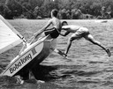
| Date: | 1959 |
|---|---|
| Description: | Two boys on the class-C scow sailboat "Bobalong III," with one boy balancing off the side while standing with one leg on the bilge keel. |
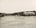
| Date: | 1959 |
|---|---|
| Description: | The Kilbourn Hydroelectric Plant of the Wisconsin Power and Light Company. |

| Date: | 1959 |
|---|---|
| Description: | Elevated view looking east from shoreline of Lake Monona towards Monona shoreline. There is a road, railroad tracks, and a rocky beach area with parked au... |
| Date: | 1959 |
|---|---|
| Description: | Elevated view looking south over Lake Monona. Shoreline and automobiles in parking lot in lower right, next to a road. Railroad tracks cross the lake and b... |

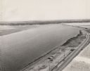
| Date: | 1959 |
|---|---|
| Description: | Elevated view of dirt parking lot between a road and the lake. Steam is rising from the lake, and the far shoreline can be seen in the distance. |

| Date: | 1959 |
|---|---|
| Description: | University of Wisconsin-Madison campus. Numbers in circles identify buildings across campus with the building index. Black arrows point out important infor... |

| Date: | 1959 |
|---|---|
| Description: | Aerial view over University Avenue of University of Wisconsin-Madison campus. Chadbourne Hall, built 1958-1959, is in the lower foreground, the Wisconsin H... |
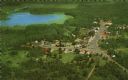
| Date: | 1959 |
|---|---|
| Description: | Color postcard of an aerial view of town. There is a lake in the background in the upper left. |

| Date: | 1959 |
|---|---|
| Description: | This map identifies public forest land and industrial forest land as of 1959 in Oneida County, Wisconsin, using a 1930 base map showing the township and ra... |

| Date: | 1959 |
|---|---|
| Description: | Photographic postcard view of cabins by a lake. In the foreground is a birch sign with antlers that reads: "Tonto." |

| Date: | 1959 |
|---|---|
| Description: | This map of Lake Geneva has relief shown by contours and water depths shown by isolines. The map includes an index of schools, churches, public services, i... |

| Date: | 1959 |
|---|---|
| Description: | This map includes directories, illustrations, and an inset location map and also covers Rock, Hog, Detroit and Plum islands. |
| Date: | 1959 |
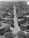
|---|---|
| Description: | Elevated view of State Street from the Wisconsin State Capitol building. Lake Mendota is on the far right. |

| Date: | 1959 |
|---|---|
| Description: | This map shows public access sites, public beaches and parks, other public shorelines, boat liveries, public hunting and fishing grounds, railroads, roads,... |

| Date: | 1959 |
|---|---|
| Description: | This colored road map shows roads in Wisconsin as well as portions of nearby states. Information on the quality and type of any road shown (expressways, St... |

| Date: | 1959 |
|---|---|
| Description: | Elevated view from hill of a waterskier and motorboat on Rock Lake. |

| Date: | 1959 |
|---|---|
| Description: | Close-up of three Brown Swiss cows at the split-rail fence in the Forest Lodge pasture. Lake Namakagon is in the background. |
If you didn't find the material you searched for, our Library Reference Staff can help.
Call our reference desk at 608-264-6535 or email us at: