 Filter: Categories of Wisconsin Historical Images
Filter: FULL_DATE of 1956
Filter: Subject of roads
Filter: Categories of Wisconsin Historical Images
Filter: FULL_DATE of 1956
Filter: Subject of roads

| Date: | 1956 |
|---|---|
| Description: | Aerial view of the South Park Street interchange. |
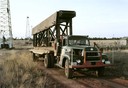
| Date: | 1956 |
|---|---|
| Description: | Color photograph of an International model R-202 oil field truck owned by M.R. Dixon. The truck is parked in an oil field with oil derricks in the backgrou... |
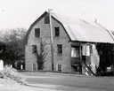
| Date: | 1956 |
|---|---|
| Description: | The stone building formerly housed the flour mill. The mill was established in 1852, but had pretty well gone out of business by 1895, by which time the po... |
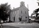
| Date: | 1956 |
|---|---|
| Description: | School known as the "old stone school," the first public school building in Bloomington. The clock tower replaced the former bell tower. |

| Date: | 1956 |
|---|---|
| Description: | Aerial view looking northeast from a point over the east end of Middleton, showing the west end of Lake Mendota (right mid-ground). Fox Bluff juts into the... |

| Date: | 1956 |
|---|---|
| Description: | Aerial view of the Sears-Roebuck department store on East Washington Avenue and its surrounding parking lots. |
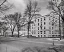
| Date: | 1956 |
|---|---|
| Description: | 1300 University Avenue. Exterior of building from across the street, with trees lining the sidewalk. In front of the building, on the left, is a curved dri... |

| Date: | 1956 |
|---|---|
| Description: | View of hospital from Park Street. A sign for the ambulance entrance under the street sign points to the right. |

| Date: | 1956 |
|---|---|
| Description: | Aerial view over University Avenue of the University of Wisconsin-Madison campus, including University farm in the upper middle. The shoreline of Lake Mend... |

| Date: | 1956 |
|---|---|
| Description: | Exterior of Chadbourne Hall on the University of Wisconsin-Madison campus. |

| Date: | 1956 |
|---|---|
| Description: | View down tree-lined sidewalk along Park Street towards University Avenue on the University of Wisconsin-Madison campus. Science Hall is on the right. |

| Date: | 1956 |
|---|---|
| Description: | Aerial view of Wisconsin General Hospital. |

| Date: | 1956 |
|---|---|
| Description: | Aerial view of Schenk's Corners where Atwood Avenue and Winnebago Street cross, looking north east. |

| Date: | 1956 |
|---|---|
| Description: | Rear view of a parade of reporters in open cars following President Eisenhower on a rural road in Iowa. The President is standing in an open car at the rig... |
| Date: | 1956 |
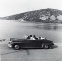
|---|---|
| Description: | Lewis, LuRay, Nellie and Bernard Arms arrive at Devil's Lake in a maroon DeSoto convertible automobile. This was the day after Lewis and LuRay's wedding. |
| Date: | 1956 |
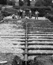
|---|---|
| Description: | "Guelig Construction workers put in a disposal system for Widmer Cheese Factory. Workers are from left, Ray Guelig, Herb Sellnow, Bob Guelig, Edgar Guelig,... |

| Date: | 1956 |
|---|---|
| Description: | This 1956 map shows sections, cities and villages, roads, railroads, and lakes and streams in the Eagle River area. All or part of the towns of Plum Lake, ... |
| Date: | 1956 |
|---|---|
| Description: | Map shows townships and sections, landownership and acreages, roads, schools, churches, and cemeteries. |

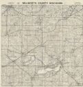
| Date: | 1956 |
|---|---|
| Description: | Shows roads, railroads, highways, boundaries, and other public facilities and areas. Includes location map and legend. "Corrected for Feb. 1956." "Correcte... |

| Date: | 1956 |
|---|---|
| Description: | Includes street index. Shows local streets, parks, highways, railroads, Fond du Lac River, and part of lake Winnebago. Also includes text on points of inte... |
If you didn't find the material you searched for, our Library Reference Staff can help.
Call our reference desk at 608-264-6535 or email us at: