 Filter: Categories of Wisconsin Historical Images
Filter: FULL_DATE of 1956
Filter: Subject of land use, urban
Filter: Categories of Wisconsin Historical Images
Filter: FULL_DATE of 1956
Filter: Subject of land use, urban

| Date: | 1956 |
|---|---|
| Description: | Aerial view of the South Park Street interchange. |
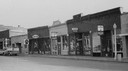
| Date: | 1956 |
|---|---|
| Description: | View across Canal Street with the businesses that were built after the fire. Ford stepside truck is parked along the curb on the left. Businesses with thre... |

| Date: | 1956 |
|---|---|
| Description: | Aerial view looking northeast from a point over the east end of Middleton, showing the west end of Lake Mendota (right mid-ground). Fox Bluff juts into the... |
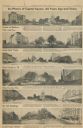
| Date: | 1956 |
|---|---|
| Description: | Capitol Square images from a 1956 Wisconsin State Journal article. |

| Date: | 1956 |
|---|---|
| Description: | Aerial view over University Avenue of the University of Wisconsin-Madison campus, including University farm in the upper middle. The shoreline of Lake Mend... |

| Date: | 1956 |
|---|---|
| Description: | International RD-190 (?) truck with an armored body, operated by the Brinks Express Company on Lake Shore Drive. |

| Date: | 1956 |
|---|---|
| Description: | International RD-190 (?) truck with an armored body, operated by the Brinks Express Company on Lake Shore Drive. Automobiles are in the background. In the ... |

| Date: | 1956 |
|---|---|
| Description: | International RD-190 (?) truck with an armored body, operated by the Brinks Express Company on Lake Shore Drive. Parked cars and a pedestrian are in the ba... |
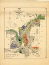
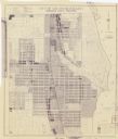
| Date: | 1956 |
|---|---|
| Description: | This map of Rhinelander shows lots, 6 types of zoning in various colors; heavy industry, light industry, commercial, residence "A," residence "unrated," lo... |
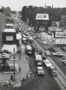
| Date: | 1956 |
|---|---|
| Description: | Elevated view looking on downtown street with traffic, in winter. |
| Date: | 1956 |
|---|---|
| Description: | This blueline print map shows streets, pedestrian pathways, plans to widen existing streets, and streets and alleys vacated and to be vacated. The upper le... |
If you didn't find the material you searched for, our Library Reference Staff can help.
Call our reference desk at 608-264-6535 or email us at: