Filter: Categories of Wisconsin Historical Images
Filter: FULL_DATE of 1956
Filter: Subject of human settlements
Filter: Creator Name of Unknown
Filter: Categories of Wisconsin Historical Images
Filter: FULL_DATE of 1956
Filter: Subject of human settlements
Filter: Creator Name of Unknown

| Date: | 1956 |
|---|---|
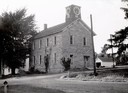
| Description: | Exterior view of the Kierig-Babbitt building, built in 1880. |
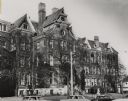
| Date: | 1956 |
|---|---|
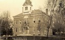
| Description: | High school. Caption reads: "High School, Bloomington Wis." |
| Date: | 1956 |
|---|---|
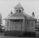
| Description: | School known as the "old stone school," the first public school building in Bloomington. The clock tower replaced the former bell tower. |
| Date: | 1956 |
|---|---|
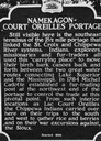
| Description: | Historical marker of the Namekagon Portage on the Lac Court Oreilles Native American Reservation. |

| Date: | 1956 |
|---|---|
| Description: | The First Lutheran Church on the corner of Randall and Milwaukee Streets. |

| Date: | 1956 |
|---|---|
| Description: | An interior view of the Grace Episcopal Church, showing the free-standing altar made of Kasota stone. The church was founded in 1838. |
| Date: | 1956 |
|---|---|
| Description: | View of the Signal Oak taken from the original, which was the first in a series of Heritage Prints. The idea for the series was conceived by the First Nati... |
| Date: | 1956 |
|---|---|
| Description: | Exterior view of monument to Milwaukeeans killed in the Second World War and the Korean Conflict. |
| Date: | 1956 |
|---|---|
| Description: | Exterior of building, which was first occupied in June 1885. It stood at the corner of 18th and Wells Streets. |
| Date: | 1956 |
|---|---|
| Description: | Flora van Brink Hony Bader (nee Melkman) in backyard of her home on Farwell Avenue. |

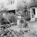
| Date: | 1956 |
|---|---|
| Description: | Friends Connie Moore (left) and LuRay (Frenchie) Arms pose comically with a motorcycle at 1851 South Park Street. Two children can be seen behind them sitt... |

| Date: | 1956 |
|---|---|
| Description: | Lewis Arms sits on the trunk of a 1949 convertible (DeSoto?) automobile, strumming a guitar. |

| Date: | 1956 |
|---|---|
| Description: | Map reads: "TAX EXEMPT LAND in the CITY OF MADISON". There is a legend of "Government Land" represented in stripes, "Religious and Fraternal Organization" ... |

| Date: | 1956 |
|---|---|
| Description: | Includes street index. Shows local streets, parks, highways, railroads, Fond du Lac River, and part of lake Winnebago. Also includes text on points of inte... |

| Date: | 1956 |
|---|---|
| Description: | This map shows local streets, roads, railroads, highways, parks, cemeteries, hospitals, the University of Wisconsin, Middleton, Maple Bluff, Shorewood Hill... |

| Date: | 1956 |
|---|---|
| Description: | The official site marker in front of the Wisconsin Historical Society Building. |
If you didn't find the material you searched for, our Library Reference Staff can help.
Call our reference desk at 608-264-6535 or email us at: