 Filter: Categories of Wisconsin Historical Images
Filter: FULL_DATE of 1956
Filter: Reproduction Rights of For Sale
Filter: Categories of Wisconsin Historical Images
Filter: FULL_DATE of 1956
Filter: Reproduction Rights of For Sale

| Date: | 1956 |
|---|---|
| Description: | This map of Racine includes a street directory and index of public buildings. Streets, points of interest, Lake Michigan, and the Root River are labeled. A... |
| Date: | 1956 |
|---|---|
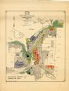
| Description: | This map of Rhinelander shows lots, 6 types of zoning in various colors; heavy industry, light industry, commercial, residence "A," residence "unrated," lo... |

| Date: | 1956 |
|---|---|
| Description: | This map is intended for tourists of La Crosse. The front of the map is text about attractions, activities, and accommodations in La Crosse. The back is th... |
| Date: | 1956 |
|---|---|
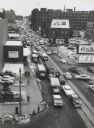
| Description: | Elevated view looking on downtown street with traffic, in winter. |

| Date: | 1956 |
|---|---|
| Description: | Quarter-length portrait of Wilbur J. Cohen, probably during his time as a Professor in Public Welfare Administration, School of Social Work, at the Univers... |
| Date: | 1956 |
|---|---|
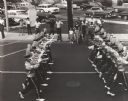
| Description: | Uniformed boys' bugle corps passing along a street in a parade. A group of people watch from the sidewalk across the street. |
| Date: | 1956 |
|---|---|
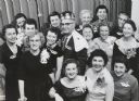
| Description: | James C. Springer of Cutler-Hammer Manufacturing Co. surrounded by members of the Milwaukee chapter of the National Secretaries' Association who had electe... |
| Date: | 1956 |
|---|---|
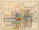
| Description: | This map shows streets and railroads and is oriented with north to the upper left. Wards have been outlined in yellow, red, blue, and green. The back of th... |

| Date: | 1956 |
|---|---|
| Description: | Group of Ladies' Sewing Club women posing under a tapestry at Neighborhood House. |

| Date: | 1956 |
|---|---|
| Description: | This maps shows voting precincts and polling places as well as wards. Streets and the Sheboygan River are labeled. The bottom right of the map features a l... |

| Date: | 1956 |
|---|---|
| Description: | Intended for tourists, this brochure features a map of Milwaukee's central business district as well as general information about parking, beaches and othe... |

| Date: | 1956 |
|---|---|
| Description: | This map shows Lake Wisconsin, roads, highways, parks, resort areas, camps, gardens, and Wisconsin State experimental game and fur farm. The back of the ma... |

| Date: | 1956 |
|---|---|
| Description: | This map shows local streets, roads, railroads, highways, parks, cemeteries, hospitals, the University of Wisconsin, Middleton, Maple Bluff, Shorewood Hill... |

| Date: | 1956 |
|---|---|
| Description: | This map shows reservation boundaries, U.S. township lines, highways, roads, rivers, and lakes. The lower left corner of the map includes a legend of "Conv... |
| Date: | 1956 |
|---|---|
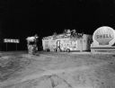
| Description: | Night view of a Shell service station with Christmas decorations. There are tree branch swags on the building and on the poles and light fixture around the... |

| Date: | 1956 |
|---|---|
| Description: | View across field towards a man driving a B-250 tractor pulling a man on a B-64 combine. |
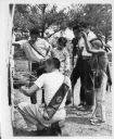
| Date: | 1956 |
|---|---|
| Description: | Six Native American boys and teenagers take part in an archery competition. They are holding their bows and carrying arrows in a bag on their backs. Riley ... |
| Date: | 1956 |
|---|---|
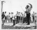
| Description: | Sam Blowsnake prepares to shoot an arrow with his bow as a crowd of people watches behind him. |

| Date: | 1956 |
|---|---|
| Description: | View of front of a V-190 with sleeper cab parked outdoors in a lot with other trucks at the Fort Wayne plant. The V-190 is pulling another V-190. RD Diesel... |

| Date: | 1956 |
|---|---|
| Description: | Driver's side view of a V-190 with sleeper cab parked in a lot. Spare wheel rim mounted on frame. The V-190 is pulling another V-190 to a dealer. Buildings... |
If you didn't find the material you searched for, our Library Reference Staff can help.
Call our reference desk at 608-264-6535 or email us at: