 Filter: Categories of Wisconsin Historical Images
Filter: FULL_DATE of 1955
Filter: Subject of railroads
Filter: Categories of Wisconsin Historical Images
Filter: FULL_DATE of 1955
Filter: Subject of railroads

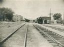
| Date: | 1955 |
|---|---|
| Description: | Chicago and Northwestern Railroad (CN&W) tracks between Brearly and Ingersoll Streets. |
| Date: | 1955 |
|---|---|
| Description: | Chicago and North Western Railroad (CN&W) tracks between Brearly and Ingersoll Streets. |

| Date: | 1955 |
|---|---|
| Description: | This 1950s tourist brochure features a map of Burnett County, Wisconsin, and northern Polk County which shows highways and roads, railroads, landmarks, and... |
| Date: | 1955 |
|---|---|
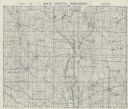
| Description: | This cadastral map shows highways, land owners, railroads, and rivers. |

| Date: | 1955 |
|---|---|
| Description: | This map shows roads, trails, county lines, town borders, section lines, railroads, rivers, lakes, and Lake Michigan on the far right. The bottom margin in... |

| Date: | 1955 |
|---|---|
| Description: | This map shows roads, golf courses, airports, fire towers, schools, camp grounds, rivers, streams, lakes, and railroads. The right margin of the map includ... |
If you didn't find the material you searched for, our Library Reference Staff can help.
Call our reference desk at 608-264-6535 or email us at: