Filter: Categories of Wisconsin Historical Images
Filter: FULL_DATE of 1955
Filter: Subject of neighborhoods
Filter: Categories of Wisconsin Historical Images
Filter: FULL_DATE of 1955
Filter: Subject of neighborhoods
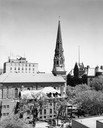
| Date: | 1955 |
|---|---|
| Description: | Elevated view of Saint Raphael's Cathedral, 216 West Main Street, with the Dane County Courthouse, 207 West Main Street, in the right background and the Pa... |

| Date: | 1955 |
|---|---|
| Description: | Aerial view of Atwood Avenue, looking west towards Winnebago Street and "Schenk's Corners." |

| Date: | 1955 |
|---|---|
| Description: | Exterior view of Central High School with cars parked in front. |
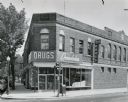
| Date: | 1955 |
|---|---|
| Description: | The Rennebohm Drug Store #5, located at 2000 Atwood Avenue, Schenk's Corners from 1952-1961. It was previously located at 1951 Winnebago Street. This store... |

| Date: | 1955 |
|---|---|
| Description: | Originally the Charles Riley house, 21 West Gilman Street. Historian Frederick Jackson Turner lived in the house in 1890. |

| Date: | 1955 |
|---|---|
| Description: | Aerial view of Mineral Point showing State Highway 23-39 under construction. |

| Date: | 1955 |
|---|---|
| Description: | Doctors Lindley and John T. Sprague house, 109 East Johnson Street. |
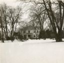
| Date: | 1955 |
|---|---|
| Description: | A distant view across snow-covered towards the residence of J.H. Osborn. Osborn moved to Oshkosh in 1844 from New York City. He farmed, traded real estate,... |
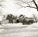
| Date: | 1955 |
|---|---|
| Description: | View from street towards the residence of J.H. Osborn. Snow is on the ground. Osborn moved to Oshkosh permanently in 1844 from New York City. He farmed, tr... |

| Date: | 1955 |
|---|---|
| Description: | Elevated view looking west at Washington School, located at 217 North Broom Street. From the early 1940's until its demolition in 1957, the school was used... |

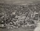
| Date: | 1955 |
|---|---|
| Description: | Aerial view of Schenk's Corners where Atwood Avenue and Winnebago Street cross, looking north west toward East Washington Avenue. ... |

| Date: | 1955 |
|---|---|
| Description: | Aerial view, looking west from over Hoyt Park toward Midvale Boulevard. |

| Date: | 1955 |
|---|---|
| Description: | Two children in winter coats and boots posing outside a building. Bricks are scattered on the ground behind them, and the building has cracked windows. |

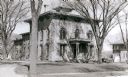
| Date: | 1955 |
|---|---|
| Description: | View from street towards the exterior of a damaged building. Bricks and boards are scattered outside it. The roof is missing, and windows are cracked or mi... |
If you didn't find the material you searched for, our Library Reference Staff can help.
Call our reference desk at 608-264-6535 or email us at: