Filter: Categories of Wisconsin Historical Images
Filter: FULL_DATE of 1955
Filter: Subject of central business districts
Filter: Categories of Wisconsin Historical Images
Filter: FULL_DATE of 1955
Filter: Subject of central business districts
| Date: | 1955 |
|---|---|
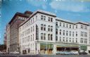
| Description: | View of downtown Madison's Park Hotel. The Prescription Pharmacy also occupies a portion of the ground floor. |
| Date: | 1955 |
|---|---|
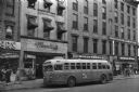
| Description: | Bus traveling down Mifflin Street on Capitol Square. Moseleys, Woldenbergs and Walgreen's Drugs are on the right. |

| Date: | 1955 |
|---|---|
| Description: | Air view of University Avenue at Midvale Boulevard. |

| Date: | 1955 |
|---|---|
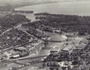
| Description: | Aerial view of the central traffic loop and Johnson Street expressway. |

| Date: | 1955 |
|---|---|
| Description: | Aerial view of the Illinois central route. The UW Fieldhouse is visible in the lower right of the image. |

| Date: | 1955 |
|---|---|
| Description: | Aerial view of Mineral Point showing State Highway 23-39 under construction. |
| Date: | 1955 |
|---|---|
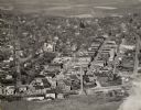
| Description: | Aerial view of "the island" with the Marathon Corporation paper mills. The Fox River flowing out of Lake Winnebago separates the two cities, Neenah and Men... |

| Date: | 1955 |
|---|---|
| Description: | The Jacob Karlan block, built in 1893 on the north side of Monroe Street. The Karlan block was erected on the site of the old United States Hotel, adjoinin... |

| Date: | 1955 |
|---|---|
| Description: | View of the State Office Building looking up at the open windows. |

| Date: | 1955 |
|---|---|
| Description: | Aerial view of Schenk's Corners where Atwood Avenue and Winnebago Street cross, looking north west toward East Washington Avenue. ... |

| Date: | 1955 |
|---|---|
| Description: | Shows city limits, adjoining municipalities, and schools. Indexes, illustrations, ancillary map of Dane County, and ancillary map of Madison business secti... |

| Date: | 1955 |
|---|---|
| Description: | A man dressed as Santa Claus leans down from an open car to hand sacks of candy to a crowd of warmly-dressed children and parents. Santa's visit took place... |
| Date: | 1955 |
|---|---|
| Description: | Black and white photographic postcard view of Ludington Street, with automobiles and pedestrians, and the Schultz Brothers store on the right. Caption read... |

| Date: | 1955 |
|---|---|
| Description: | Photographic postcard of Ludington Street at an intersection, with automobiles and local businesses. Caption reads: "Ludington St., Columbus, Wis." |
| Date: | 1955 |
|---|---|
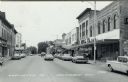
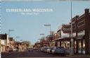
| Description: | View down street of commercial buildings. Text on back reads: "A friendly city of prosperous, industrious people in a farming and vacationers' paradise. 'T... |

| Date: | 1955 |
|---|---|
| Description: | View across Mifflin Street, towards Madison City Hall as it is being demolished. On the street women are walking around the construction to get to the side... |
| Date: | 1955 |
|---|---|
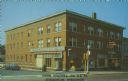
| Description: | Text on front reads: "Hotel Kegonsa — On U.S. 51, Stoughton, Wisconsin." On reverse, "Hotel Kegonsa, Modern Coffee Shop, U.S. Highway 51, Stoughton, Wiscon... |
If you didn't find the material you searched for, our Library Reference Staff can help.
Call our reference desk at 608-264-6535 or email us at: