 Filter: Categories of Wisconsin Historical Images
Filter: FULL_DATE of 1955
Filter: Subject of airports
Filter: Categories of Wisconsin Historical Images
Filter: FULL_DATE of 1955
Filter: Subject of airports
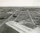
| Date: | 1955 |
|---|---|
| Description: | An aerial view of Truax Field, now also called Dane County Regional Airport. In addition to commercial flights, Truax Field is also home to the Army Nation... |
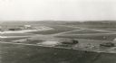
| Date: | 1955 |
|---|---|
| Description: | An aerial view at Truax Field showing the Municipal Airport Administration Building. |

| Date: | 1955 |
|---|---|
| Description: | This map shows roads, golf courses, airports, fire towers, schools, camp grounds, rivers, streams, lakes, and railroads. The right margin of the map includ... |
If you didn't find the material you searched for, our Library Reference Staff can help.
Call our reference desk at 608-264-6535 or email us at: