 Filter: Categories of Wisconsin Historical Images
Filter: FULL_DATE of 1955
Filter: Community of Madison
Filter: Subject of human settlements
Filter: Categories of Wisconsin Historical Images
Filter: FULL_DATE of 1955
Filter: Community of Madison
Filter: Subject of human settlements
| Date: | 1955 |
|---|---|
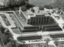
| Description: | Aerial view of the Forest Products Laboratory. |

| Date: | 1955 |
|---|---|
| Description: | Originally the Charles Riley house, 21 West Gilman Street. Historian Frederick Jackson Turner lived in the house in 1890. |

| Date: | 1955 |
|---|---|
| Description: | The Grace Episcopal Church Rectory on West Washington Avenue, built in 1893 and razed in 1960. |
| Date: | 1955 |
|---|---|
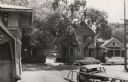
| Description: | The intersection of Johnson and Broom Streets. |

| Date: | 1955 |
|---|---|
| Description: | Doctors Lindley and John T. Sprague house, 109 East Johnson Street. |

| Date: | 1955 |
|---|---|
| Description: | A public bus crosses the bridge over a ravine on Lake Mendota Drive in Shorewood, looking east. |

| Date: | 1955 |
|---|---|
| Description: | Bridge over a ravine on Lake Mendota Drive in Shorewood Hills, looking west. |

| Date: | 1955 |
|---|---|
| Description: | View down Monona Avenue, which is now Martin Luther King, Jr. Boulevard, toward Lake Monona. |

| Date: | 1955 |
|---|---|
| Description: | A view looking northeast along Main Street from near its intersection with Monona Avenue on Capitol Square. |
| Date: | 1955 |
|---|---|
| Description: | View of two houses (108 N. Blount and 102 N. Blount) on North Blount Street taken from Market Place showing a corner of the City Market on the left. |

| Date: | 1955 |
|---|---|
| Description: | Midvale Avenue and Odana Boulevard. |
| Date: | 1955 |
|---|---|
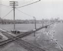
| Description: | Elevated view of the Milwaukee Road and Chicago & Northwestern Railway crossing on Monona Bay, the site of the old MX tower. |

| Date: | 1955 |
|---|---|
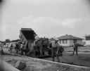
| Description: | Blacktopping a new Madison residential street. Construction of the ranch-style houses in the background is almost complete. |
| Date: | 1955 |
|---|---|
| Description: | A construction crew blacktopping a Madison residential street. |

| Date: | 1955 |
|---|---|
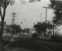
| Description: | East Washington Avenue near Union Corners when first reopened after widening in 1955. Several vehicles are on the road. |

| Date: | 1955 |
|---|---|
| Description: | View of the State Office Building looking up at the open windows. |
| Date: | 1955 |
|---|---|
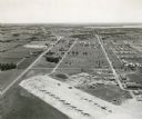
| Description: | An aerial view of Truax Field, now also called Dane County Regional Airport. In addition to commercial flights, Truax Field is also home to the Army Nation... |
| Date: | 1955 |
|---|---|
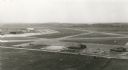
| Description: | An aerial view at Truax Field showing the Municipal Airport Administration Building. |

| Date: | 1955 |
|---|---|
| Description: | Elevated view looking west at Washington School, located at 217 North Broom Street. From the early 1940's until its demolition in 1957, the school was used... |
If you didn't find the material you searched for, our Library Reference Staff can help.
Call our reference desk at 608-264-6535 or email us at:
