 Filter: Categories of Wisconsin Historical Images
Filter: FULL_DATE of 1955
Filter: Community of Madison
Filter: Subject of aerial photographs
Filter: Categories of Wisconsin Historical Images
Filter: FULL_DATE of 1955
Filter: Community of Madison
Filter: Subject of aerial photographs

| Date: | 1955 |
|---|---|
| Description: | Aerial view of Midvale neighborhood under construction near Madison's southwestern city limits. The view is focused on the area bounded by Tokay Boulevard,... |

| Date: | 1955 |
|---|---|
| Description: | An air view of Madison's downtown area with the Wisconsin State Capitol and new State Office Buildings. |

| Date: | 1955 |
|---|---|
| Description: | Aerial view of Atwood Avenue, looking west towards Winnebago Street and "Schenk's Corners." |

| Date: | 1955 |
|---|---|
| Description: | Aerial view of the central traffic loop and Johnson Street expressway. |

| Date: | 1955 |
|---|---|
| Description: | Aerial view of the Illinois central route. The UW Fieldhouse is visible in the lower right of the image. |
| Date: | 1955 |
|---|---|
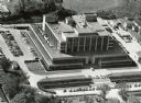
| Description: | Aerial view of the Forest Products Laboratory. |
| Date: | 1955 |
|---|---|
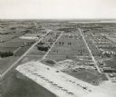
| Description: | An aerial view of Truax Field, now also called Dane County Regional Airport. In addition to commercial flights, Truax Field is also home to the Army Nation... |
| Date: | 1955 |
|---|---|
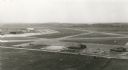
| Description: | An aerial view at Truax Field showing the Municipal Airport Administration Building. |

| Date: | 1955 |
|---|---|
| Description: | Aerial view of Schenk's Corners where Atwood Avenue and Winnebago Street cross, looking north west toward East Washington Avenue. ... |

| Date: | 1955 |
|---|---|
| Description: | Aerial view, looking west from over Hoyt Park toward Midvale Boulevard. |
If you didn't find the material you searched for, our Library Reference Staff can help.
Call our reference desk at 608-264-6535 or email us at:
