 Filter: Categories of Wisconsin Historical Images
Filter: FULL_DATE of 1954
Filter: Subject of michigan, lake
Filter: Categories of Wisconsin Historical Images
Filter: FULL_DATE of 1954
Filter: Subject of michigan, lake
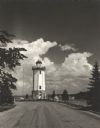
| Date: | 1954 |
|---|---|
| Description: | View down road towards the Fond du Lac lighthouse, built in 1933. There are cumulus clouds in the sky, and pine trees are lining the shore. |

| Date: | 1954 |
|---|---|
| Description: | View looking west from Eagle Bluff toward Nicolet Bay, the Strawberry Islands, and Chambers Island. Three people are sitting on the stone wall of the overl... |

| Date: | 1954 |
|---|---|
| Description: | This map shows the location of Catholic churches, missions, and shrines. The map is color coded and includes a key in the bottom left corner. The back of t... |
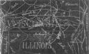
| Date: | 1954 |
|---|---|
| Description: | This photocopy map shows a early sketch of the settlement Southport. Rivers, lakes, other settlements, county boundaries, and roads are labeled. A portion ... |
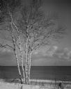
| Date: | 1954 |
|---|---|
| Description: | Birch trees in the snow on the shore of Lake Michigan. |
If you didn't find the material you searched for, our Library Reference Staff can help.
Call our reference desk at 608-264-6535 or email us at: